Large easing surf ahead of another large swell late week

Western Australia Surf Forecast by Craig Brokensha (issued Friday 14th June)
Best Days: Tuesday, Wednesday, Thursday in the South West, Friday morning
Recap
Average onshore and smaller surf across the South West on the weekend, while Mandurah was a good and clean 2-3ft Saturday, back to 2ft on Sunday. Perth was a small 1-2ft all weekend.
Today our extra-large long-period SW groundswell has filled in with clean and improving 10-12ft waves across the South West this morning, 3-4ft in Mandurah and 2-3ft in Perth, while we should see a secondary larger increase this afternoon to 12-15ft, 4ft and 3ft respectively across all locations. Cape Naturaliste is showing this spike of new swell and winds are still favourable.

Today’s Forecaster Notes are brought to you by Rip Curl
This week and weekend (Jun 18 - 23)
As discussed in this forum thread here, the wave model data is incorrect for the coming week owing to an update we did over the weekend. With the model starting from scratch, the swells for today, easing through tomorrow and Wednesday are non-existent.
We'll see today's mix of extra-large swells easing tomorrow from 10-12ft across the South West, 3ft+ in Mandurah and 2-3ft in Perth along with a E/NE-NE tending N/NW breeze around Margs, limiting surfing options. Perth and Mandurah should see more favourable E/NE tending lighter N/NE winds.
 Wednesday will be clean again with E/NE offshore winds as the SW groundswell continues to ease, smaller into Thursday with a persistent E/NE offshore, best across the Margaret River swell magnets.
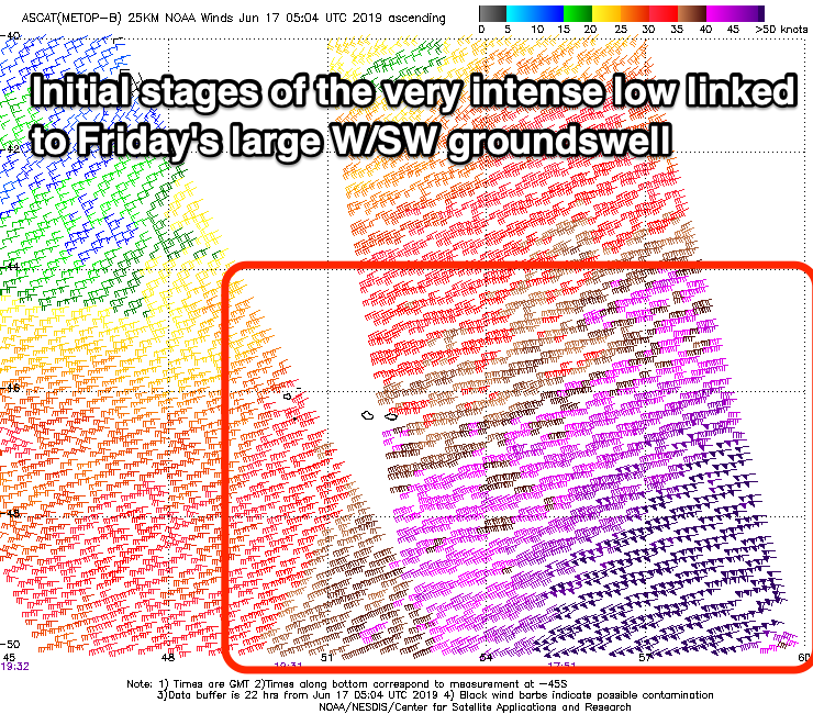
Our large long-period W/SW groundswell for Friday is still on track, and as the models missed the initial stages of the very intense low that formed under South Africa, the timing and size of this swell is off on our wave charts.
A great and significant fetch of storm-force W/SW winds have been projected through our far western swell window, with the storm now around Heard Island at strength. It'll slowly ease while continuing east over the coming days, with the swell arriving late Thursday and peaking through Friday to an inconsistent 10-12ft across the South West, if not for the odd sneaky 15ft cleanup, 3-4ft in Mandurah and 3ft in Perth.
Winds look like they'll take a NE tendency on Friday morning, N/NW into the afternoon and then poor from the N tending N/NW Saturday as the swell eases.
Longer term we're set to endure another episode of large stormy swell from late in the weekend into early next week as a flurry of strong frontal systems push up and into us owing to a broad node of the Long Wave Trough moving in aross us. More on this Wednesday.
Comments
Large and empty this arvo..
Love how Margies goes about doing its thing without the hype
How's this sequence from the Margs cam this arvo.. all one wave. Check the last frame!


It was a good day Ben. Wait till you see the impressive pic RO took of JM's first wave, it was a ripper.