Clean though small weekend, more action next week

Western Australia Surf Forecast by Craig Brokensha (issued Friday 29th March)
Best Days: Swell magnets tomorrow morning, dawn Monday in the South West, Tuesday protected spots, Wednesday morning
Recap
Small to tiny surf yesterday with poor and gusty S/SE winds, while today a new SW groundswell has lifted wave heights across the South West to 3-4ft with early favourable winds.
Today’s Forecaster Notes are brought to you by Rip Curl
This weekend and next week (Mar 30 – Apr 5)
We've got a clean weekend of surf ahead but with no new swell, so Perth and Mandurah will become unsurfably small while the magnets across the South West look the pick tomorrow, very marginal Sunday.
Today's swell will ease and you'll probably find some 3ft leftovers on the magnets, back to the small to tiny stuff Sunday ahead of a late afternoon and inconsistent increase in long-period SW groundswell.
Winds tomorrow will be good and moderate to fresh out of the E, easing and tending more E/NE ahead of late sea breezes. Sunday will offer E/NE offshore winds tending lighter from the N into the afternoon.
The long-period SW groundswell won't have too much size to it, but should provide fun waves on Monday. Ben pegged this swell down to an inconsistent 3-4ft across Margs, but looking at the raw model data I feel we could see the odd bigger 5ft'er, while Perth and Mandurah will remain tiny.
 Winds will do a dosey-doe on Monday as a surface trough approaches from the east. At dawn an OK NE'ly is expected but this will swing NW ahead of a S/SW change, so the window for a clean wave will be very limited.
Tuesday doesn't look too flash as the swell eases with S/SE winds, though a small new mid-period SW swell should keep waves around 4ft in the South West. This will be generated by a small and intense low over the weekend, producing a tight fetch of W/SW winds. Mandurah may see 1-1.5ft sets, while Perth will remain tiny.
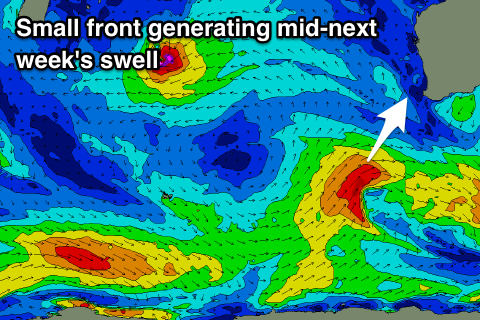
Into the middle of the week a better S/SW swell is due across the state, produced by a broader though relatively weak frontal system moving in behind the low.
We'll hopefully see a kick in size to 4-5ft Wednesday across the South West, 1ft to maybe 2ft in Mandurah and a tiny 1ft+ in Perth. The best thing about this swell are the local winds, with an offshore E/SE wind, stronger from the S'th into the afternoon.
Longer term storms will continue to be blocked out of our swell window by a strong high sitting west-southwest of the state, but we may see a significant polar low forming in the south-west corner of one of these highs. If so a large long-period S/SW groundswell could be on the cards for Monday week, but more on this Monday. Have a great weekend!