Easing surf ahead of large surf again into next week

Western Australia Surf Forecast by Craig Brokensha (issued Wednesday 6th March)
Best Days: Monday morning, Tuesday, Wednesday morning
Recap
Our large long-period SW groundswell came in right on forecast yesterday with strong offshore winds but large building surf to 10-12ft across the South West yesterday afternoon, 3ft in Mandurah and 2-3ft in Perth with all day offshore winds.
The swell dropped rapidly to the north leaving inconsistent small 2ft leftovers in Mandurah, tiny across Perth, while Margs was excellent again with clean 4-6ft sets as shown at dawn this morning in the image below.

Today’s Forecaster Notes are brought to you by Rip Curl
This week and weekend (Mar 7 - 10)
The surf will continue to ease through tomorrow though winds look funky and variable across the South West, likely NW at dawn then tending S/SE through the morning. Size wise Margs looks to ease from 3-4ft, tiny in Perth and Mandurah.
Friday will be a bit smaller again and a small mid-period S/SW swell for the afternoon and Saturday has been downgrade a little. Instead the surf will be average with leftover 2-3ft sets max in the South West with a S/SE-SE breeze.
Saturday looks cleaner with a SE breeze, but no new size, while into Sunday a new mix of mid-period and long-period SW groundswell are due to build, followed by a larger and more powerful S/SW groundswell Tuesday.
The first swell will be generated by a strong low swinging in from the Heard Island region, generating a fetch of W/SW gales which will be projected towards us and then the Bight.
 The timing of the swell increase Sunday is hard to pin down but we're likely to see a small spike in the morning ahead of a late increase in size, peaking Monday morning to 6-8ft in the South West, 2ft to possibly 3ft in Mandurah and 2ft in Perth. Winds on Sunday aren't great, but Monday should see a morning SE breeze ahead of afternoon sea breezes.
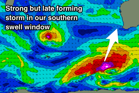
The larger and more powerful S/SW groundswell will be generated by a late forming storm in our southern swell window, with a fetch of severe-gale to storm-force W/SW winds projecting towards SA and Victoria.
The South West should still see sets to 8ft+ across exposed breaks, 2-3ft in Mandurah and 1-2ft in Perth. Winds will be great and out of the E/SE, back to the S/SE as the swell eases Wednesday.
Longer term we may see a new swell later week, but more on this Friday.