Finally a more significant swell for next week

Western Australia Surf Forecast by Craig Brokensha (issued Friday 15th February)
Best Days: Sunday and Monday mornings in the South West, Wednesday in the South West, all locations Thursday
Recap
Poor conditions across all locations yesterday with S'ly winds in the South West and a drop in swell, tiny to the north.
This morning the surf cleaned up across the South West with lingering 3-4ft sets, tiny and clean to the north.
Today’s Forecaster Notes are brought to you by Rip Curl
This week and weekend (Feb 16 - 22)
We'll see the surf really bottom out tomorrow with no decent size left across the South West and with a morning S/SE breeze, strengthening from the S'th into the afternoon.
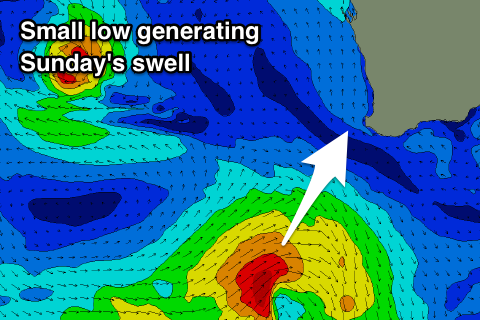 Our small spike in mid-period SW swell for Sunday is still on track, with a small low forming south-west of us yesterday evening. A tight fetch of strong to gale-force SW winds have been generated in our south-western swell window, moving more into our southern swell window during today.
This should produce a fun pulse of mid-period SW tending S/SW swell Sunday coming in at 4ft across swell magnets in the South West, tiny to the north.
The swell will ease through Monday but a secondary pulse of S'ly swell should be seen Tuesday morning, produced as the low stalls south of us on the weekend, projecting a slow moving fetch of gale to severe-gale S/SW winds in our acute southerly swell window.
Size wise Monday will likely only be small and easing from 3ft across Margs, while the S'ly swell Tuesday may provide 4-5ft sets across pure south facing locations, but more so around the other side of the cape. Perth and Mandurah will become tiny to flat.
Coming back to the local winds and Sunday looks great with an E/SE offshore, lasting until early-mid afternoon while Monday should see an even straighter E'ly offshore ahead of mid-afternoon sea breezes.
Winds won't be good for those spots seeing the S'ly swell Tuesday with a S-S/SW breeze due across all locations.
We've got an upgrade in the swell due through the middle to end of next week now and with favourable winds.
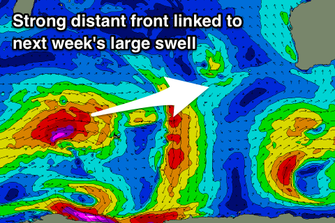 A strong frontal system that's currently south-east of South Africa will move through our far swell window, generating a small fetch of severe-gale W/SW winds, becoming smaller but maintaining strength while moving north of Heard Island.
The front is then expected to strengthen slightly again south-west of us, producing a broader fetch of W/SW gales before pushing east-northeast and weakening under the country.
With the front being so long lived we'll see a mix of groundswells, the long-period energy very inconsistent but both arriving the same time through Wednesday morning and building to 6-8ft across the South West by later in the day, 2-3ft in Mandurah and 2ft in Perth.
Thursday should offer similar sized sets and we may even see the odd bigger cleanup set to 10ft in the South West over the peak of the swell.
Winds on Wednesday should be good in the morning and offshore out of the SE, only S/SE into the afternoon while Thursday looks excellent with a straight E-E/NE offshore. We'll confirm all of this on Monday though. Have a great weekend!