Fun couple of days before deteriorating towards the weekend

Western Australia Surf Forecast by Craig Brokensha (issued Monday 11th February)
Best Days: Tuesday morning in the South West, Wednesday morning, Sunday and Monday mornings in the South West
Recap
Clean though small and inconsistent waves on the coast Saturday morning, bumpier into yesterday morning. Further north conditions were tiny to flat.
A slight lift in size was seen today but conditions were average across the South West and bumpy to the north as well, still tiny.
Today’s Forecaster Notes are brought to you by Rip Curl
This week and weekend (Feb 12 - 17)
After an average run of surf, we've luckily got some better groundswell on the way for the South West, though its southerly direction will limit the size expected further north.
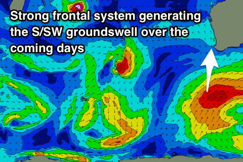
This moderate to large S/SW groundswell was generated over the weekend and this morning by a strong polar frontal progression. A good fetch of SW gales were projected from south-southwest of us towards our South Coast, with the front now pushing towards the Bight.
We should see the swell filling in tomorrow and building to an easy 6ft across exposed reefs to the incoming southerly direction, if not more now later in the day, easing back from 5-6ft Wednesday morning. Mandurah should kick to 2ft later in the day and ease from a similar size Wednesday on the sets, with 1-1.5ft waves up in Perth.
Conditions tomorrow morning as the swell starts building look good with a SE breeze, likely tending E/SE at periods ahead of afternoon sea breezes. Wednesday then looks excellent with a straight offshore E'ly wind, tending variable ahead of sea breezes.
 The rest of the week will be average as the S/SW swell rapidly declines and with S-S/SE winds on Thursday, S/SE on Friday morning.
The models are still picking up small hints of long-period W/NW groundswell from tropical cyclones Funani and Gelena from Wednesday through Saturday but I wouldn't expect anything over infrequent 1-2ft sets max across Perth and Mandurah.
Our next increase in swell is due to arrive from a stalling low that will develop south-west of us Friday. An initial fetch of strong W/SW winds will generate a small mid-period SW swell for later Saturday and more so Sunday, with a secondary S/SW groundswell pulse due Monday afternoon and Tuesday from a stalling fetch of SW gales south of us on the weekend.
Local winds look favourable and best Monday, with a deepening surface trough likely to bring onshore breezes from Tuesday with no decent swell. More on this Wednesday.