Mixed conditions and swells but windows of opportunity

Western Australia Surf Forecast by Craig Brokensha (issued Monday 21st January)
Best Days: Protected spots early tomorrow, Friday morning, Saturday morning, Sunday morning, Monday morning
Recap
Good small, clean waves across the swell magnets Saturday morning in the South West, tiny to flat to the north.
Our new large SW groundswell pushed in yesterday and conditions were great early with a SE breeze, but onshore SW winds kicked in mid-morning while to the north it was tiny early with onshore bigger surf into the afternoon.
This morning the swell was hanging in there but conditions were average in the South West, bumpy but fun with 2-3ft sets in Mandurah, 1-2ft in Perth.
Today’s Forecaster Notes are brought to you by Rip Curl
This week and weekend (Jan 22 – 27)
We'll see conditions improve across all locations tomorrow as winds tend S/SE, but they'll be fresh so protected spots will be the best. The swell will be smaller though and easing off from 4-5ft across the South West, 2ft in Mandurah and tiny in Perth.
A strong mid-latitude low forming off our coast during the middle of the week will see winds swing from an overnight offshore E/NE'ly to the N/NW-NW at dawn Wednesday, creating poor conditions while bringing an increase in windswell.
The windswell will build out of the NW, and reach a stormy 3ft+ across Perth and Mandurah with Margs seeing similar sized waves though from a more acute N/NW direction.
The low is forecast to move across us into the evening, bringing a strong SW change and SW windswell for Thursday but with poor S/SW winds. There's not expected to be any size to the SW windswell.
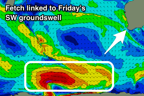 Friday is looking much better with winds swinging SE along with a new long-period SW groundswell on the build.
The swell has already started to be generated by a strong polar low that formed west of Heard Island. A fetch of severe-gale W/NW winds have been generated and we'll see the low continue east while generating W'ly gales in our swell window before weakening Wednesday morning.
A large long-period SW groundswell should be seen, building Friday and reaching 6ft+ across the South West, 2ft+ in Mandurah and 1-2ft in Perth. There should be a bit of size before sea breezes kick in, before the swell eases Saturday with less favourable S/SE winds.
A new mid-period SW swell is expected on Sunday as a weak though broad polar front projects up towards us through the second half of the week, generating a fetch of strong SW winds.
Sets around 6ft are expected on Sunday across the South West, with 2ft waves in Mandurah and 1-2ft sets in Perth as winds improve and swing SE through the morning.
It looks like we'll see fun backup swells through most of next week with favourable SE morning winds as the frontal activity continues to our south-west, but we'll look over this again on Wednesday.
Comments
Interesting overnight wind plot from Cape Leeuwin
Yeah with this low in the region..
Yep, not very often you get one going straight over the top, usually just the flanking edge with centre of the low sitting further south