Better swells with OK but not great winds

Western Australia Surf Forecast by Craig Brokensha (issued Monday 26th November)
Best Days: South West swell magnets tomorrow morning for desperate surfers, Thursday morning protected spots, Friday morning, Sunday morning protected spots
Recap
A poor weekend of waves with no decent size and dicey winds across the South West, cleaner to the north.
Today a new kick in swell has been seen to 3-5ft across the South West though with cross-shore winds, cleaner though only 1-1.5ft in Mandurah and Perth.
Today’s Forecaster Notes are brought to you by Rip Curl
This week and weekend (Nov 27 – Dec 2)
Today's small bump in swell is expected to ease off this afternoon and drop further tomorrow but with great conditions for swell magnets across the South West.
A morning E/NE wind is expected, giving into an onshore W/SW-SW change early afternoon so go the early for easing 3ft sets in the South West, 1ft and tiny to the north.
A fun new pulse of mid-period SW swell is expected to build Wednesday, generated by a relatively weak but good polar fetch of strong to gale-force W/SW winds east of Heard Island yesterday and today.
This should provide 4-6ft sets across the South West magnets into the afternoon, 1-2ft in Mandurah and 1-1.5ft in Perth, undersized early.
 Winds aren't ideal and look S/SE early ahead of a strong onshore S/SW change.
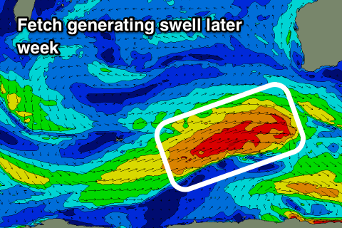
Before the swell gets to ease on Thursday a new longer-period SW groundswell is due to build through the day, peaking later before easing through Friday.
This will be generated by a better fetch of W/SW gales projecting up towards us through Tuesday and Wednesday.
Sets should reach 8ft across Margs later in the day, easing from 6-8ft Friday, with 2-3ft sets in Mandurah and 2ft in Perth, easing from similar sizes Friday morning.
Winds on Thursday will be gusty and strengthen through the day from the S/SE with better and lighter SE winds Friday morning.
We're set to see yet another swell on the weekend, produced by a smaller tighter low forming late in our swell window. A burst of W/SW-SW gales will be generated late in our swell window, producing a S/SW groundswell pulse for Saturday, building to 6ft+ across South West magnets into the afternoon, 2ft+ in Mandurah and 1-2ft in Perth.
Winds look onshore from the S/SW though as the low clips the southern coastline of the state, cleaner Sunday with S/SE winds.
Longer term we may see another large long-period SW groundswell for mid-next week, but more on this Wednesday.