Fun waves over the coming days as conditions improve

Western Australia Surf Forecast by Craig Brokensha (issued Monday 19th November)
Best Days: All coasts tomorrow morning, Margs and Mandurah Wednesday morning, swell magnets in the South West Thursday morning
Recap
A good window of clean conditions early Saturday with a fun new swell across the South West, 2ft in Mandurah and tiny but bumpy in Perth. Conditions deteriorated from mid-morning as an onshore change moved through, with poor waves across all locations yesterday.
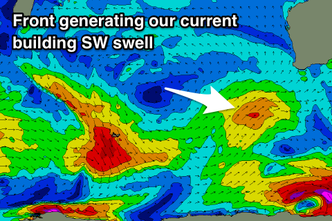
Today a mix of easing SW groundswell from yesterday afternoon and building mid-period SW swell are breaking across the state but with poor onshore winds again in the South West, cleaner to the north and to 2ft in Mandurah, 1-1.5ft in Perth.
Today’s Forecaster Notes are brought to you by Rip Curl
This week and weekend (Nov 20 - 25)
This afternoon's mid-period SW swell has already hit the 6ft range across the South West, and with a peak due tomorrow morning, we'll likely still see easy 6ft+ waves across the reefs, easing slowly through the day, down further into Wednesday from 4-5ft.
Mandurah should see 2-3ft sets, 1-2ft in Perth, easing through the day and smaller from 2ft and 1-1.5ft respectively Wednesday.
Conditions look favourable and offshore across Mandurah and Perth tomorrow morning with a S/SE-SE breeze, while Margs looks a little dicey but OK in protected spots with a S-S/SE breeze.
 Don't expect as much size in these protected spots as usual under a 6ft+ groundswell, as the swell energy will be much weaker and surf smaller.
Wednesday looks great with a gusty E/SE offshore tending variable ahead of sea breezes.
Thursday is also shaping up clean again but smaller and only surfable across the South West magnets to 3-4ft.
A new small SW groundswell is due on Friday but it will be generated by a small fetch of unfavourably aligned pre-frontal NW gales between us and Heard Island.
Mandurah and Perth will remain tiny and Margs may see infrequent 3ft+ sets on the magnets.
Winds look poor in any case as a deepening trough moves east, swinging winds from the S/SE to S/SW across all locations.
The weekend isn't great with onshore winds and no decent swell, while a strengthening polar front projecting towards us through the weekend should generate a new mid-period SW swell for early next week but with onshore winds Monday, improving into Tuesday. We'll have a closer look at this in Wednesday's notes though.