Back to back large swells, cleanest as they ease

Western Australia Surf Forecast by Craig Brokensha (issued Wednesday 31st October)
Best Days: Saturday morning, protected spots Monday, Tuesday morning, Wednesday morning
Recap
Better waves across the South West yesterday afternoon though still a bit raw with a gusty SE wind and 4-5ft of swell, building further in size into the afternoon. Winds were cross-shore further north with a small 1-2ft wave in Mandurah, 1-1.5ft in Perth.
This morning better size was seen across the South West with offshore winds and clean pumping 4-6ft sets, 2ft in Mandurah and 1-2ft in Perth.
Today’s Forecaster Notes are brought to you by Rip Curl
This week and early next week (Nov 1 - 6)
Tomorrow isn't looking too flash with today's swell due to ease back this afternoon, further tomorrow morning along with strengthening onshore W/SW winds across the South West, while Perth and Mandurah may see a dawn S/SE breeze but they'll be tiny.
Our large SW groundswell for Friday is still on track, with a vigorous polar front currently positioned east of Heard Island. We'll see this front project a good fetch of W/SW gales up towards us this afternoon and tomorrow, continuing slowly east through Friday.
A large mid-period SW swell will fill in Friday, building to 6-8ft across the South West, 2-3ft in Mandurah and 2ft in Perth but with onshore S/SW winds. Perth and Mandurah may see early S/SE-SE winds but with no major size.
 Saturday is still the day to surf as winds go offshore out of the SE to possibly E/SE in the South West along with easing surf from 6ft+ across the South West, with E/SE offshores and easing 2-3ft waves in Mandurah and 2ft sets in Perth.
A deepening mid-latitude low will drift south and then east into Sunday bringing onshore SW winds, possibly S'ly early to the north but with no major size.
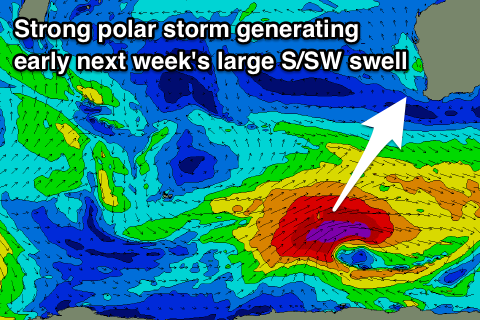
We've then got a larger S/SW groundswell on the cards for early next week as a vigorous polar storm develops south-west of us and is directed up towards the Bight under the influence of a strong node of the Long Wave Trough.
We'll see a polar fetch of severe-gale to storm-force W/SW winds generated in our southern swell window before the storm moves off to the east out of our swell window.
A large long-period S/SW groundswell should be produced, filling in Monday and building to a large 8-10ft across the South West, 3ft on the sets in Mandurah and 2ft in Perth. Winds will be out of the S'th, offshore Tuesday as the swell eases, similar Wednesday. We'll confirm this on Friday though.