NW Cyclone swell peaking Sunday afternoon

Western Australia Surf Forecast by Craig Brokensha (issued Friday 23rd March)
Best Days: Saturday morning across the South West, later in the day Perth and Mandurah, all coasts Sunday, dawn Monday, Thursday morning
Recap
Poor conditions across all coasts yesterday with small to tiny surf, increasing through the afternoon, while this morning we've got a bit more swell but less than ideal conditions.
Mandurah and Perth have been clean but tiny.
Today’s Forecaster Notes are brought to you by Rip Curl
This week and weekend (Mar 24 – 30)
We've got an exciting weekend of surf ahead with a rare and clean NW groundswell due to impact the entire state.
First though, a mid-period SW swell is due to build through tomorrow, generated by a relatively weak though broad polar frontal system pushing through our swell window the last couple of days.
 We should see the swell build tomorrow, reaching 3-5ft later in the day across the South West, tiny up in Mandurah and Perth, easing from 4ft or so Sunday morning.
Winds tomorrow will be gusty from the SE across the South West, tending more S/SE into the afternoon, with E/SE winds further north.
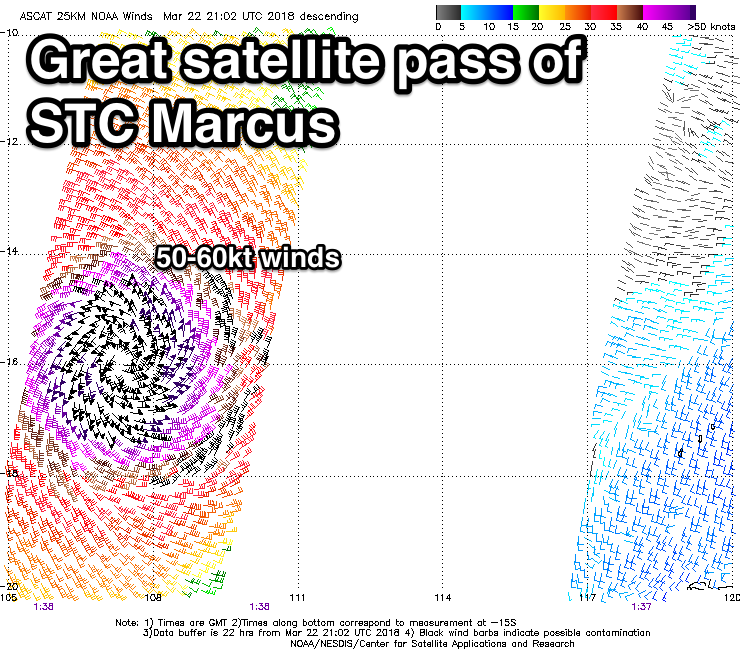
Looking at Severe Tropical Cyclone Marcus and satellite observations are incredible with a perfectly structured system visible along with hurricane-force winds aimed towards the West Australian coast.
The North West is expected to get very large later today and tomorrow, though winds are looking dicey.
Looking at the Perth, Mandurah and Margaret River regions though, and we'll see STC Marcus tracking south through today and tomorrow while slowly weakening but continuing to aim a fetch of hurricane-force tending gale-force N/NW winds through our north-western swell windows.
Comparing Marcus to Bianca, Bianca held a bit more strength but came in from a wider position and pushed down closer to Perth, while Marcus a bit closer to the coast, but will weaken quicker.
We'll also see a bit more north in Marcus' swell so you'll have to head to exposed north facing breaks for the most size. Any regular south-west or west facing break will see much smaller surf.
Also locations south of about Prvelly will also see much smaller surf as the coast bends away to the south-southeast.
Timing wise, the swell is due to now peak a little later, more so midday across Perth to a strong 4ft across spots exposed to the north-west, with Mandurah coming in at 4-5ft through the middle of the day/afternoon. Keep an eye out for small lines of N/NW groundswell later Saturday though.
Margs is looking small early Sunday, with the NW groundswell arriving through the late morning and peaking into the afternoon/evening around 5-6ft on the sets. There's the possibility for some larger bomb sets at times across all locations, more so later in the day and winds are looking excellent with fresh gusty E'ly offshores, easing a little and tending a little more E/NE into the afternoon. This will favour some breaks but not others exposed to the NW groundswell.
It should also be noted that with such a rare swell event, allow some elasticity on the timing of the swell peak, as cyclones are tricky beasts and be prepared to seatch the coast a bit for the best waves.
Come Monday Marcus will be much weaker and will track south-west across the Margaret River region bringing early NE tending N/NW and then S/SW winds. Perth and Mandurah will see less favourable N/NE winds at dawn. The NW groundswell will be on a steady drop as well.
Looking at the rest of the week and we've got a good SW groundswell event on the cards from Wednesday through Thursday due, produced by a slow moving polar frontal progression pushing up towards us over the weekend and early next week.
The swell won't be the strongest but will be consistent with building surf to 6-8ft later in the day across the South West Wednesday, 2-3ft in Mandurah and 2ft in Perth.
The swell should then ease slowly through Thursday, further Friday.
Winds will unfortunately remain onshore through Tuesday and Wednesday, hopefully tending more S/SE-SE on Thursday. We'll have another look at this Monday though. Have a great weekend!
Comments
Its fair to say previous weekend plans have been ditched! C'mon Marcus bring us the goods!!!
Sunday is fun day
North facing coastline hmmmmm. where could that be ?
Swell pumping up here in Exmouth ,dodgy onshores not helping though
How about Geraldton / Kalbarri?
http://www.abc.net.au/news/2018-03-23/cyclone-marcus-cyclone-nora-two-ot...