All about Marcus

Western Australia Surf Forecast by Craig Brokensha (issued Monday 19th March)
Best Days: South West swell magnets tomorrow and Wednesday, all coasts Saturday and Sunday, Margs Monday morning
Recap
Poor conditions with a building windswell Saturday followed by stronger groundswell Sunday and improving conditions as winds swung more offshore through the morning ahead of sea breezes. Margs came in around 5-6ft with 2ft surf in Mandurah, smaller in Perth.
This morning conditions were again clean with easing levels of swell, fun in the South West but tiny to the north.
Today’s Forecaster Notes are brought to you by Rip Curl
This week and weekend (Mar 20 – 25)
The surf will continue to ease through tomorrow but with favourable winds for magnets across the South West.
Fresh E/NE winds are due all morning and early afternoon, tending variable ahead of possible late sea breezes. We're looking at small easing 3ft+ waves across swell magnets in the South West, tiny elsewhere.
 A new S/SW groundswell is due to arrive later in the day but peak Wednesday morning, generated by a very strong but late forming polar frontal progression under the country.
South swell magnets in the South West should hopefully see surf in the 4ft range with a great E/NE offshore breeze through the morning again, tending variable ahead of late sea breezes.
We'll see a temporary low point in activity Thursday morning and with onshore S/SW winds as a surface trough slides in from the west.
This will also spoil a new S/SW groundswell that's due into the afternoon, generated by a strong polar low that's currently east of Heard Island.
A fetch of severe-gale to storm-force W'ly winds are being generated in our southern swell window, with Margs expected to kick to 3-5ft, tiny around Mandurah and Perth.
Friday should be cleaner as the trough moves east, bringing fresh SE-S/SE winds, though with the south swell direction, options with decent size will be limited.
Moving into the weekend we turn our eye Tropical Cyclone Marcus.
TC Marcus is currently a category 2 cyclone, positioned just north of Broome and will continue tracking west while strengthening over the coming days.
What we're interested are the developments once Marcus moves west of Exmouth and into our swell window.
Current guidance has Marcus reaching category 5 status on Wednesday morning north of Exmouth, weakening slowly as it starts to then turn the corner and head south down our coast.
Cyclones are very tricky systems to forecast with super strong winds covering such a small area, and with Marcus, the strongest and best fetch will be on its south-western flank (aimed into the Indian Ocean) as it squeezes against a high in the Indian Ocean.
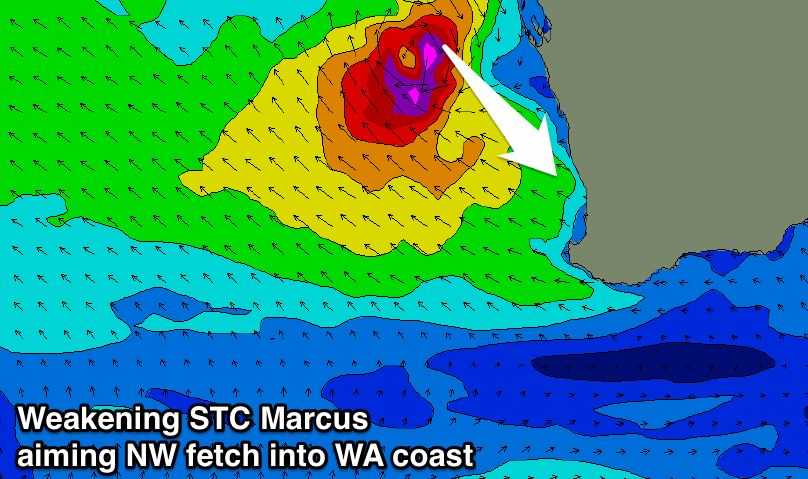 This will be mainly aimed towards the Maldives, with a much smaller fetch of NW winds aimed through our north-west swell window.
With Marcus situated far from our coasts, well north-west of Exmouth, we'll see hurricane force NW winds directed towards the northern half of our state through Friday, with winds really backing off as it drifts south and weakens over the weekend well west of Geraldton.
What we can expect is a large pulse of NW groundswell for the northern half of the state, building Friday out of the N/NW and peaking Saturday from the NW in the 10ft range.
This swell will filter down into Perth later Saturday, likely reaching 2-3ft later in the day and peaking Sunday to 4ft. Mandurah will see a slightly later arrival time and possibly a touch more size, while the track of Marcus isn't as ideal for Margs, with an acute N/NW groundswell building to 4-6ft during Sunday at exposed north facing breaks. There'll be a wide variation of size though with the acute north angle in the swell, so keep this in mind when hunting for surf.
Winds are looking best for locations south of the axis of Marcus which means the northern half of the state will be poor as the swell peaks with onshore NW winds.
Perth and Mandurah should see gusty E/SE tending SE winds Saturday swinging E/NE to NE on Sunday as the remnants of Marcus dip south. Margs should see good offshore E/SE-SE winds on Saturday, more E/SE Sunday and persisting all day.
Come Monday the swell will drop rapidly as winds swing onshore as Marcus pushes south-east inland.
Also in the mix on the weekend across the South West will be a mid-period SW swell to 4ft later Saturday, easing Sunday, but more on this Wednesday when we'll reassess the strength and track of Marcus.
Comments
What's going to happen on saturday night in the middle of the indian ocean when a westerly swell period collides with Marcus's easterly swell period??
They'll pass through each other. We get similar south and north-east swells passing through each other all the time on the East Coast.
I find that fascinating
hollowjono - at the point of convergence a mega swell will develop generating epic waves for the mid west region
Craig ,
Was thinking about this today .
With the peak in the STC intensity during a Due South travel path and a long way from the SW / Rottnest . Any chance the peak intensity ( Period & Size ) pre winds will see some Benouli Curvature . Ie actually clock in from a more NW direction . The shelf alignment should also help the swell refract into shore on the longer period energy . Its a shame it will transition so far North . Definitely no Alby , but the cold core may surprise if it maintains cut off status long enough .
Wow, thanks for the idea Southey, I Googled Benouli Curvature and learnt something I've never come across before.. Brachistochrone curve.
This theory depends on gravity though in a vertical plane, not movement on a horizontal plane as Marcus is.
Regardless, I think with the location of Marcus off the WA coast we'll see the swell coming in from the NW across Perth and more N/NW around Margs.
Looking deeper, it doesn't just have to be gravity, but some acceleration in that plane. I'm not sure Marcus will be under a constant acceleration over this time period, resulting in the swell taking this curve. Very interesting though.
Yep my Bad . i meant Coriolis . Very similar though .
stoked! should be some interesting setups
Craig, Ben said this: “Reefbreaks that are usually slow and fat can light up with lengthy hollow sections, and lonely beachbreaks normally sheltered from large south-west swells can fire with perfect A-frames if their alignment and bathymetry is bang on with the incoming energy”
Craig, do you agree that rather than W/SW facing beaches picking up this swell, it could be NW facing beaches ( that usually don’t get much swell) that are the ones to watch?
I’m thinking of one beach near me that faces direct SSW, (offshore in NNE winds) it doesn’t generally pick up much swell ( due to offshore reefs) but I can imagine a NW swell hitting it sideways and peeling. Whatdyareckon... Or will the NW swell simply bypass beaches like this?
Yes, locations facing pure north-west will see the most size, but also unless there's a reef or good bank, closeouts.
It depends on how much sheltering that south-southwest facing beach has from headlands to its north, offshore reefs and swell buffering bathymetry to how much size gets in. Some spots yes, other spots no.
Any update on how it’s tracking?
A good time to get the helicopter or plane to fly by and find new surf breaks along the coast . It could be a trip of a lifetime worth making .
Like it Clam, definitely worth the journey. Thought about this on rare swell circumstances plenty of times but never eventuated. Really ain’t that much $$$ between 3 to 4 friends. Fortunate enough to have flew over cloudbreak and surrounds once, just on a medium/small swell but it was a sight to see. Total glass off, pits galore reeling off endlessly. Only two very lucky souls out that day. Unfortunately winds picked up from the nor east from that moment forth and it was Wilkes pass at 2-4 foot for 6 days straight. Who am I to complain, i’m a natural anyways, give me rights for days any day of the week
I’m making one of those trips right now to a spot that would probably be unfuckingbelievable. Too bad I’ll be a few days late and the cyclone could very well fuck up every plan we’ve made.
Tropical Cyclone Marcus is heading for Perth, but you don't need to panic
By Rebecca Dollery
Posted 12 hours ago, updated 6 hours ago
"Forecasters say a severe tropical cyclone set to curve around the WA coast towards Perth is the strongest of the season, but have assured the public there is no cause for alarm."
http://www.abc.net.au/news/2018-03-21/cyclone-marcus-is-heading-for-pert...
Here's a clip my brother took today of the swell, not bad considering it was onshore.
"Waves hit heights of up to four metres at Cape Naturaliste in the state's South West and up to two-and-a-half metres off Rottnest Island with Cottesloe fetching just over one metre swell, Mr Colangelo said."
https://www.smh.com.au/national/western-australia/perth-surfers-enjoy-ra...
It had seemed that the Naturaliste buoy was broken .
Wondering if theres any truth to the 4m that the bureaus Gianni said ?
Rotto and mandurah buoys were both about 2m @15.9s from what i remember. Cott was ~ 1m @16
Maybe a tad above 2m on rotto .
So it seems Gianni has some credibility.
Personally doubt that it even got to 3m
(if say that the buoy was correctly reading , On the same mid day spike as rottnest and mandurah).
"according to Bureau of Meteorology duty forecaster Gianni Colangelo."
Was it actually 4m or was the dotr buoy malfunctioning ?
Why would he say 4m ?
Good point Clam,
If it was 4m @16s and from the SW it would have been much bigger. The Nat buoy was out when I checked it a couple of times that day. Less than 3m would be a good estimate.
As a reference, Bianca's swell in 2011 hit about 9am, 305 degrees, and 1.75m swell height and 13s period. Swell peaked about 1pm @3.2m, 12.5s, and still 305 degrees. I think Marcus had more North in it though, so probably skimming more continental shelf to make landfall (reducing wave height).