Great waves Sunday, XL swell for next week

Western Australia Surf Forecast by Craig Brokensha (issued Friday 9th June)
Best Days: Protected spots around Margs Saturday morning, Sunday, Monday morning, Wednesday protected spots
Recap
Large clean pumping waves yesterday, easing from the 10ft range in the South West and 3ft+ in Mandurah with 2-3ft waves further north.
Today the swell was smaller and winds more NE with easing 4-5ft sets in the South West and 2ft waves further north.
This weekend (June 10 – 16)
Tomorrow isn't looking too flash, but there'll be a few options around Margs with an early fresh N/NE offshore, tending more N'ly through the day.
The swell will be smaller though and around the 4ft range across the South West, tiny further north.
Later in the day some new long-range W/SW groundswell is due, produced south-east of South Africa earlier this week, with a peak due Sunday morning.
Margs should see inconsistent 6-8ft+ sets across exposed breaks with 2ft to occasionally 3ft waves further north. Winds are now looking great as a small low forms and stalls to our west, directing offshore E/NE winds across most breaks all day.
 Winds will tend from the E/NE Monday morning more NE into the afternoon as Sunday's swell eases.
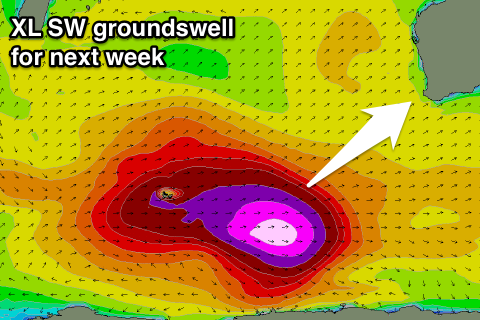
We then look ahead towards the XL swell due through the middle of next week.
Looking at the latest model guidance and it looks like the swell will peak overnight, with XL surf seen on dark Tuesday and into Wednesday morning.
This swell will actually be linked to the large pumping swell seen at Skeleton Bay, with the storm generating this swell drifting south-east from South Africa, into the Southern Ocean before re-intensifying in the Heard Island region.
Various bursts of severe-gale westerly winds will be aimed through our far western swell window, with core wind speeds reaching the storm-force range. One of the final intensifications will see severe-gales produced on top of the already active sea state generated before it, resulting in an XL swell event.
The long-period energy is due to fill in Tuesday with peak periods likely to register around 22s during the morning. We should see the swell build rapidly behind this with wave heights climbing to the XL range on dark, peaking overnight with XL reinforcing energy Wednesday.
Size wise we're probably looking at inconsistent sets building to 12ft by dark, with possible 15ft bombs, holding a similar 12ft to occasionally 15ft Wednesday before easing Thursday. Perth should increase to 2-3ft late in the day Tuesday with 3ft surf through Wednesday.
Winds Tuesday are still a little up in the air but we're probably looking at N'ly winds, giving into an afternoon S/SW change which is average, and then Wednesday looks to see S/SE winds, favouring protected spots.
We'll have one last look at this and the expected swell size Monday though.
Longer term there's plenty more moderate to large size swell due later next week and into the weekend, but more on this Monday. Have a great weekend!