Small windows of clean waves in the South West

Western Australia Surf Forecast by Craig Brokensha (issued Friday 25th November)
Sign up to Swellnet’s newsletter and receive updates on when the West Australian Forecaster Notes are looking better as well as the latest news sent directly to your inbox. Upon signup you'll also enter the draw to win a surf trip to P-Pass for you and a mate. It doesn’t get much easier so click HERE to sign up now.
Best Days: South West dawn Saturday, dawn Monday, Wednesday morning
Recap
Tiny clean surf around Perth and Mandurah yesterday and today, while Margs was a smallish 3ft yesterday morning, a bit bigger today with a new W/SW groundswell.
Another stronger increase in W/SW groundswell is due across the state this afternoon as sea breezes kick in.
This weekend and next week (Nov 24 – 27)
This afternoon's swell should reach an inconsistent 4-5ft+ across exposed breaks in the South West, peaking overnight and then easing off from a similar size tomorrow morning, down further from 3-5ft Sunday.
Remember there will be very long waits between sets, so you'll have to be patient. Perth isn't due to see much size above 1ft if that.
The early is the go tomorrow with a moderate E/NE-NE breeze due, tending N/NW by late morning and then S/SW into the afternoon,
Sunday will then see fresh and gusty S/SE winds (likely tending SE at times through the morning) leaving protected breaks with the best conditions but less zize.
Into Monday a mix of very inconsistent long-range SW groundswell from under South Africa, and building medium-range SW swell is expected.
Margs should see inconsistent 3-4ft sets through the morning, with slightly bigger sets showing into the afternoon as the medium-range energy fills in.
 This will be generated by a pre-frontal fetch of strong to gale-force W/NW winds north of the Heard Island region today.
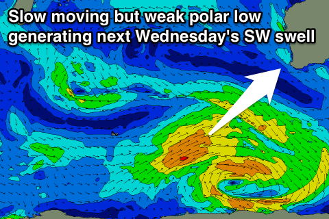
A secondary slightly stronger and closer fetch of W/NW to W/SW winds on Sunday, stalling into Monday should produce some more consistent and slightly better swell for Tuesday and Wednesday.
Tuesday looks to be around 3-4ft+, while Wednesday's pulse should be more to 4-5ft.
Perth will only be around 1ft with these swells.
Winds on Monday morning should be E/SE offshore, but swinging more SE by mid-morning and then onshore into the afternoon. Tuesday is then a little average with S/SE breezes, while Wednesday is the pick with an E/SE offshore all morning.
Longer term some small SW and S/SW swell are due late week of a forming low to our south, nothing thereafter. But more on this Monday. Have a great weekend