Small average swells through the week, strong long-period groundswell for the weekend

Western Australia Surf Forecast by Craig Brokensha (issued Monday 31st October)
Best Days: Margs Tuesday and Wednesday mornings, Margs Saturday morning, both regions Sunday morning
Recap
Solid onshore waves Saturday across the South West, smaller and average to the north. Sunday was much better with easing 6-8ft sets around Margs under S/SE winds, and smaller 2ft sets around Perth.
Today similar conditions were seen with easing 4-5ft sets in the South West and 1-2ft up in Perth.
This week (Nov 1 - 4)
We'll see much cleaner conditions across the South West tomorrow with offshore E/SE breezes developing through the morning, but size wise there isn't due to be much above 3-4ft on the exposed reefs. Perth and Mandurah will be tiny.
A slight increase in S/SW swell is expected on Wednesday from a strong polar front that formed right on the edge of our swell window to our south.
Perth isn't expected to see any major size at all with tiny 1ft waves, but Margs should see 3-4ft+ sets across south magnets, easing back through Thursday morning as some new SW swell fills in to a similar size. The source of this swell will be a less than favourably aligned pre-frontal fetch of W/NW winds through our south-western swell window.
Conditions on Wednesday should be clean again across the South West with a morning SE tending E/SE breeze ahead of afternoon sea breezes, while an onshore change is due Thursday.
Another small pulse of SW swell is expected from the front attached to the change Friday, but not above 3-4ft+ or so across the South West again. Tiny and to 1ft in Perth. S/SE winds will create less than ideal conditions in any case on Friday.
 This weekend onwards (Nov 5 onwards)
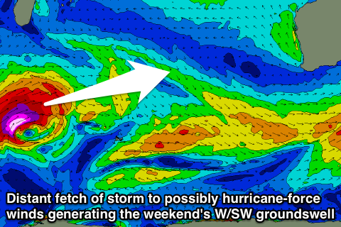
Of greater importance is a moderate to large and very long-period but inconsistent W/SW groundswell due over the weekend (mainly Sunday).
The source of this swell, which was discussed by Ben in Friday's notes, is looking a lot better on the charts, with a more consolidated and vigorous low pressure system currently developing south of South Africa today.
This tight and intense low will generate a fetch of severe-gale to storm-force W/SW winds, possibly even reaching hurricane-force over some 24 hours. The low will stall which is great for a pro-longed and larger swell event, but the only problem is the distance between the source of the swell and our coasts.
It's a very long way and with this there'll be a fair bit of swell decay as the swell crosses the Indian Ocean.
Long period fore-runners to 22s or so are due to show on the buoys early Saturday morning, generated by the strongest core winds, but the bulk of the swell will be some 24 hours behind, peaking through Sunday.
Therefore through Saturday a very slow and inconsistent upwards trend in size is expected, with nothing of significance through the morning, before sets reach the easy 6ft range into the mid-late afternoon. Perth isn't due to see any major size above 1-1.5ft.
A peak is due through Sunday to 6-8ft with 10ft bombs sets across the South West, but very very inconsistent. 2ft+ waves are on the cards for Perth (2-3ft Mandurah).
Winds will be offshore Saturday morning ahead of afternoon sea breeze, with Sunday seeing less favourable S/SE tending S/SW winds, S'ly Monday. We'll have a closer look at this Wednesday though.