Large stormy W/SW swell tomorrow, easing into Friday, cleaner and better from Sunday

Western Australia Surf Forecast by Craig Brokensha (issued Wednesday 7th September)
Best Days: Perth Friday morning, early Saturday, both coasts Sunday morning, South West early next week
Recap
Good conditions early yesterday with 2ft sets around Perth and 5-6ft sets in the South West. The afternoon was poor though with a gusty N/NW breeze developing across the state.
Today onshore stormy waves are being seen across the coast with strong onshore winds.
This week and weekend (Sep 8 - 11)
Today's large building storm swell is from the first of two vigorous fronts pushing into us.
The second is currently moving in from the west-southwest and will push across us later this afternoon, generating an additional large pulse of W/SW groundswell for tomorrow.
Large 12ft+ waves are due across the South West, 3-4ft in Perth with fresh onshore SW winds, easing back steadily through the late morning and then swinging more W/NW.
The swell should start easing later in the afternoon, easing more steadily from 8-10ft and 3ft respectively Friday morning.
Onshore winds will continue in the South West from the W/NW while Perth should see an early light offshore wind.
Our strong SW groundswell for Saturday is still on track, with a vigorous polar low currently forming east of Heard Island, to our south-west.
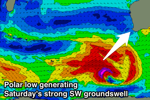 A pre-frontal fetch of W/NW gales will set in motion an active sea state for a stronger fetch of severe-gale to storm-force W/SW winds to move over.
The swell should fill in Saturday and reach 8-10ft across exposed breaks in the South West and 2ft+ in Perth.
Conditions will remain less than ideal around Margs with an early weak W/SW wind, giving into a S/SE change through the day. Perth should see variable tending light offshore winds early.
Sunday looks much better though with a fresh SE offshore across the South West and Perth (possibly E/SE) as the swell eases back from 6-8ft and 2ft respectively.
Next week onwards (Sep 12 onwards)
Good offshore E/SE winds are due into early next week as the SW swell continues to ease. This easing trend should be slowed slightly by a reinforcing S/SW groundswell Monday afternoon across the South West.
4-5ft+ waves are due, smaller into Tuesday.
Longer term some small to moderate sized S/SW groundswell is on the cards for Wednesday, with a slightly lager swell for Friday, but more on this in Friday's update.