Average for most of the week, great from Friday

Western Australia Surf Forecast by Craig Brokensha (issued Monday 29th August)
Best Days: Thursday morning keen surfers, Friday onwards
Recap
Poor conditions to start the weekend with an onshore building S/SW swell across the South West, easing from a choppy 6ft+ Sunday morning. Perth jacked to 2-3ft Saturday, easing back from a similar size Sunday as onshore winds continued from the S/SW.
The swell was much smaller this morning but a bit cleaner with a light S'ly in the South West and 1-2ft or so around Perth with lumpy conditions under a light SE breeze.
This week (Aug 30 – Sep 2)
During tomorrow a very inconsistent long-range SW groundswell is due to build, generated in our far swell window last week south-east of South Africa.
A slow increase in size is due, building to 6ft on the sets into the afternoon across Margs, with 1-2ft waves mid-late afternoon across Perth.
A secondary pulse of SW groundswell is then due for Wednesday morning from the secondary intensification of the polar low generating tomorrow's swell, around the Heard Island. A fetch of severe-gale to storm-force W/NW winds were produced in our swell window, with more consistent 6ft surf due across Margs, continuing around 2ft in Perth.
Winds tomorrow morning ahead of any real size are due to be from the NE-E/NE across both regions, freshening from the NW into the afternoon.
Wednesday will then be poor with a S/SW change moving through (W/NW early around Perth).
Into Wednesday afternoon, one final pulse of W/SW swell is expected off the progression from last week, a piggy-backing front moving more through our western swell window.
This swell should buuld to a slightly stronger 6ft+ across the South West and 2ft+ around Perth, easing from a similar size Thursday. Conditions will finally improve Thursday with a S/SE'ly around Margs and SE winds in Perth.
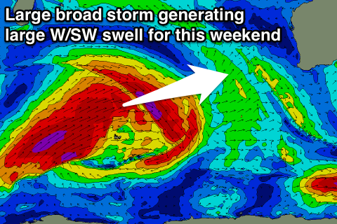 As touched on last update, from Friday and into the weekend we're expecting large levels of W/SW groundswell to impact the state, owing to a strong node of the Long Wave Trough moving through the southern Indian Ocean.
An initial pulse of W/SW groundswell is due Friday morning from a good pre-frontal fetch of severe-gale W/NW winds, coming in around 4-6ft in the South West and 1-1.5ft in Perth.
A better aligned and broader fetch of post-frontal W/SW severe-gales will generate a larger W/SW groundswell for later Friday and Saturday, coming in at 10ft+ across the South West and 2-3ft further north.
Conditions are looking great for Friday through the weekend with light morning offshores, variable into the afternoons over the weekend. We'll confirm this Wednesday though.