Winds continue to spoil swell pulses

Western Australia Surf Forecast by Craig Brokensha (issued Monday 18th July)
Best Days: Early tomorrow both regions, Sunday morning
Recap
Poor onshore 6-8ft waves Saturday in the South West with more size to 8-10ft on Sunday. Perth was a small messy 2ft on Saturday with more size to 2-3ft Sunday as strong onshore winds continued.
This morning conditions finally improved with solid easing 8ft+ sets in the South West, 3-4ft waves around Mandurah and 3ft sets in Perth.
This week (Jul 19 - 22)
Our current W/SW groundswell will ease this afternoon and continue to drop into tomorrow but our window of early clean conditions across the South West looks to have been shortened.
A variable breeze should be seen across the northern half of the cape, better and offshore from the E/NE to the north before increasing W/NW winds develop.
Onshore NW winds will then wreck a new SW groundswell that's due to fill in Wednesday, generated by a fetch of severe-gale to sub-storm-force W/SW winds currently moving through our south-western swell window.
We should see the South West building to 6-8ft through the afternoon with 2ft+ waves around Perth, easing from a similar size Thursday morning but with onshore SW winds.
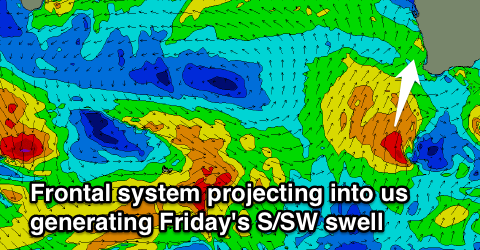 Later in the day Thursday and more so Friday a new large S/SW groundswell is due from a strong polar front projecting right up and into us through the middle to end of the week.
We should see the South West kicking to the 8-10ft range through the day Friday with Perth building to 2-3ft into the afternoon with easing onshore S/SW winds.
Saturday is unfortunately looking average as the swell eases with onshore W'ly tending S/SW winds, with slightly more favourable S/SE winds possible Sunday.
Another large pulse of S/SW groundswell is on the cards for Sunday afternoon but we'll have a closer look at this Wednesday.