Large swells, cleanest around Perth

Western Australia Surf Forecast by Craig Brokensha (issued Friday 13th May)
Best Days: Perth Monday, Tuesday, Wednesday, Thursday, South West Thursday morning
Recap
Bumpy small 3-4ft waves across the South West yesterday, with cleaner conditions to the north and 1-1.5ft sets.
Today a new W/SW swell is filling in with larger sets to 5ft across the South West but with a poor and freshening NW breeze, while Perth saw cleaner and fun 1-2ft sets. We should see the surf build through this afternoon further but with average winds across all coasts.
This weekend and next week (May 14 – 20)
Over the coming period we're set to see a series of large groundswells but mostly with average winds.
The first is due to build tomorrow, generated by a vigorous and slow moving polar frontal progression that developed west of Heard Island earlier this week.
This swell should build through tomorrow, reaching a large 10-12ft by dark across the South West and 2-3ft in Perth. Sunday is likely to see similar sized sets, easing back through the day.
Conditions tomorrow will be poor across all locations with a fresh onshore W/SW tending W'ly breeze (easing off across Perth, so maybe a late session is worth a look).
Sunday is then due to see strong W/NW tending W/SW winds across the South West, with similar but weaker winds to the north, creating poor conditions.
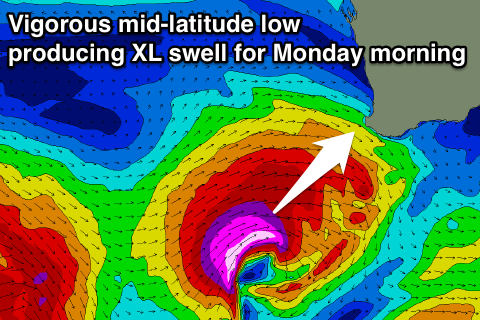 Our oversized W/SW-SW groundswell for Monday morning is still on track, with a vigorous mid-latitude low forecast to develop west-southwest of us this evening before projecting a fetch of severe-gale to storm-force W/SW winds through our western and then south-western swell window tomorrow and Sunday.
A XL swell should result, peaking Monday morning across the South West to the 15ft range across exposed breaks, larger at deep water offshore reefs. Perth should kick to a solid 3-4ft by mid-morning.
Now, winds are the tricky part. Perth and Mandurah look excellent with offshore E/NE tending variable winds, but the Margs regions is expected to see moderate W'ly winds, freshening through the day from the NW with an approaching front. This won't leave many options for a decent wave at all.
The swell will ease quickly through the afternoon and further Tuesday due to the rapid movement of the low east.
Come Tuesday we're only expecting to see half the size with easing 6-8ft sets. Fresh W/NW winds will continue to create poor conditions in the South West, with a morning offshore to the north.
Later in the day but more so Wednesday another large pulse of groundswell is expected, this one from the SW.
This will be generated as a vigorous polar frontal progression develops west of Heard Island but projects north-east towards us while generating a fetch of severe-gale SW winds, with storm-force cores in its final stages before weakening.
A large long-period SW groundswell should be generated, peaking Wednesday morning to 12ft+ across the South West and 3ft in Perth. Conditions will remain average with a moderate onshore W/SW breeze across the South West but cleaner conditions around Perth.
Thursday looks clean on the backside of the swell, but more on this Monday. Have a great weekend!
Comments
OMG!
lots of options north and west of perth come monday
Go west side
I was going to fly in for this swell . But something come up for work that was immovable . Spewing .
Great readings off Albany. 6.5m around 17/18s..
Yeah but no one on swellnet cares theyre busy awaiting a 3ft windswell
Craig seeing we are looking at this buoy do you have any ideas why thr direction refuses to go any more west than now ?
Just from obs elsewhere , I doubt you'll get wave buoys ( unless they are a LONG way offshore ) read any direction of solid swell at less than 30 degs acute from the general geographical alignment of that regions coast . ( average over 100's of Kms) .
So in this instance 40-50 km's offshore , off the continental shelf they might be more west , but at that size /period its refracting in from a more Sth direction at nearshore locales .
The only excpetion to this might be canyon or offshore ridges focusing a swell or realigning it .
Yeap southey I was hoping for more info , & I guessed that was how it worked , all the wa buoys have their own range of direction and rarely go beyond that scope