Mediocre week and weekend again

Western Australia Surf Forecast by Craig Brokensha (issued Monday 22nd February)
Best Days: Wednesday morning, Thursday morning, Friday morning
Recap
Great conditions for exposed breaks over the weekend with offshore winds and small waves in the 3ft range.
Today some new long-range SW swell is breaking across most coasts, mixed in with a more consistent and weaker SW windswell along with fresh SW winds.
This week (Feb 23 - 26)
The better and more consistent pulse of SW groundswell for tomorrow is still on the cards, generated by a good looking cold front moving through our swell window over the weekend.
Better 4-6ft sets are due across swell magnets in the South West with 1-2ft waves around Perth and Mandurah but unfortunately winds are due to remain onshore from the SW, lighter up around Perth early.
Wednesday will be cleaner as winds tend SE, even possibly E/SE for a period around Margs but with easing levels of swell from 3-5ft.
 Thursday is the day to surf with E/SE offshores but small leftover amounts of easing SW swell from 3-4ft.
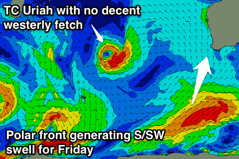
Later in the day we may see a new S/SW groundswell pushing into the coast, generated by a strengthening but late forming polar front (in our swell window) to our south tomorrow.
A fetch of SW gales will be generated on the edge of our swell window with maybe 3ft to possibly 4ft sets at swell magnets, fading through the day. Conditions will be good again though with offshore E/SE winds.
This weekend onwards (Feb 27 onwards)
Unfortunately we're not expected to see any swell from Tropical Cyclone Uriah as it weakens through the Indian Ocean and doesn't develop any decent westerly fetch.
With this easing levels of small S/SW swell are due with light offshore winds Saturday morning and variable S'ly winds Sunday ahead of an onshore change.
Longer term a moderate sized SW groundswell is on the cards for next week, but we'll have a closer look at this in the next update.