Strong but acute S'ly swell tomorrow, nothing too major after

Western Australia Surf Forecast by Craig Brokensha (issued Monday 1st February)
Best Days: Wednesday morning exposed breaks in the South West, swell magnets Thursday morning, Sunday and Monday mornings exposed breaks in the South West
Recap
Clean but small leftovers across swell magnets Saturday morning, while Sunday was tiny and onshore early ahead of a building S/SW swell through the day. Further north an afternoon increase in windswell was seen into the afternoon.
Today poor conditions and choppy 4-5ft waves were seen in the South West, while Mandurah offered cleaner and peaky 2ft sets, coming in at 1-1.5ft or so around Perth.
This week (Feb 2 - 5)
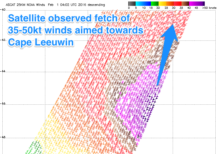 Currently, an intense mid-latitude low has formed to our south, with a fetch of severe-gale to storm-force S/SW winds picked up by satellite, just on the edge of Margaret River's swell window. The low will remain stationary through until this evening before moving east and weakening tomorrow.
A strong but very acute S/SW groundswell will be generated, building tomorrow afternoon to 6ft+ across only exposed breaks to the south, tiny in protected locations, with no decent size further north. The morning should see smaller 3-5ft waves out of the S/SW, 1-1.5ft to the north.
Conditions will be average at spots picking up the most size with S/SE tending S/SW winds around Margs, cleaner to the north with SE offshores.
After a peak into the evening, a rapid drop in size is expected into Wednesday with fading 3-5ft sets at spots exposed to the south, much much smaller elsewhere. Better offshore E/SE winds are expected ahead of afternoon sea breezes.
Better E/NE tending NE winds are due Thursday favouring swell magnets, but only small inconsistent 2-3ft waves are due, so head to those spots that are known to draw in every bit of swell.
For the rest of the period there's nothing too significant on the cards, with a flurry of broad but not overly strong, polar frontal activity due to produce small inconsistent pulses of SW groundswell.
The best pulses are due Sunday through Wednesday next week but only to 3-4ft+ or so across exposed breaks in the South West.
There's no real end to this pattern still on the long-range charts, but we'll have a closer look at this on Wednesday though.