Fun swell Thursday/Friday, average S/SW swell from Sunday

Western Australia Surf Forecast by Craig Brokensha (issued Monday 25th January)
Best Days: Thursday mid-late morning onwards, Friday, early Saturday swell magnets
Recap
Small to tiny surf across the South West, best at swell magnets with decent winds Saturday morning, more from the SE Sunday. Perth was tiny and better for a swim than surf.
This morning the small waves continued with nothing really of note across the coast, even with a slight kick in mid-period SW swell.
This week and weekend (Jan 26 – 31)
The coming couple of days aren't looking too flash with small surf continuing under morning SE winds. There'll be no decent options for a wave, so give the arms a further rest.
Our new SW groundswell for Thursday is still on track, with a strong polar low to our south-west currently producing a fetch of SW gales.
A small to moderate sized SW groundswell should result peaking through Thursday to 4-5ft across exposed breaks in the South West, with 1ft+ waves up in Perth through the afternoon.
Conditions are looking better for this swell, although offshore E/SE winds will be strong through the morning, ease late morning and into the middle of the day before tending S/SE.
A drop in swell is due Friday with fresh and gusty E'ly winds (possible E/NE at times), tending more variable into the afternoon.
Saturday will be smaller again, with inconsistent 3ft+ sets likely across swell magnets in the South West, ahead of a slight kick in background SW groundswell through the afternoon.
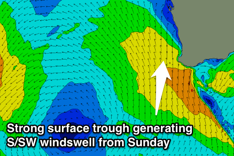 Early NE winds should favour swell magnets, before shifting NW into the afternoon ahead of an approaching and deepening surface trough.
This trough will be quite broad and strong, aiming a fetch of strong S/SW winds up the WA coast through Sunday, followed by stronger gale-force S/SW winds as a deep low pressure system forms south of Cape Leeuwin.
This is expected to producing building levels of S/SW windswell through Sunday along with strong S/SW winds, easing a touch back into Monday ahead of a S/SW groundswell pulse Tuesday morning.
Conditions will remain poor Monday though with SW winds, continuing from the S/SW Tuesday.
Size wise exposed spots around Margs should increase to 4-6ft Sunday afternoon, easing back to 3-5ft Monday ahead of a final kick Tuesday morning to 5-6ft.
Perth should see 1-2ft of windswell Sunday, easing back a touch Monday and further Tuesday.
Longer term there's still nothing major on the cards, but check back here Wednesday for the latest.