Workable weekend and next week

Western Australia Surf Forecast by Craig Brokensha (issued Friday 8th January)
Best Days: Saturday, Sunday and Monday mornings in the South West, Wednesday protected spots in the South West, Thursday morning
Recap
Good fun waves easing from 3-5ft or so across the South West yesterday with stiff offshores, easing through the day.
Perth and Mandurah were tiny and only good for a slide on a longboard or other fun board.
The swell dropped rapidly into the afternoon leaving small to tiny waves today as offshores persisted.
This weekend and next week (Jan 9 – 15)
A good new pulse of long-range and inconsistent SW groundswell is due through tomorrow afternoon in the South West, building to 5-6ft across exposed breaks, with Perth not seeing any size until Sunday with infrequent 1ft to possibly 2ft sets.
Early offshore E/NE winds are due to swing moderate NW into the afternoon across Margs, creating less than ideal conditions.
Sunday morning looks workable with variable breezes ahead of afternoon sea breezes across both coasts.
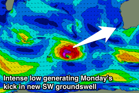 Into Monday a fresh pulse of SW groundswell is due across the state, generated by a tight and intense low pushing east while producing a weakening fetch of severe-gale W/SW winds.
Margs should build to 5-6ft through the day at exposed spots, with Perth kicking back to 1ft to maybe 2ft. Winds will be OK but not great with a light to moderate S/SE breeze, favouring slightly protected breaks.
The stronger secondary low talked about on Wednesday is now not due to be as strong or powerful, with it due to intensify once passing through the Bight out of our swell window.
Instead we'll see this relatively weak low bring onshores through Tuesday and a close-range SW swell building later in the day, peaking Wednesday afternoon to 4-6ft in the South West and 1ft to maybe 2ft around Perth.
Winds should improve as the low pushes east with a fresh S/SE'ly Wednesday and better E/SE offshores as the SW swell eases quickly through Thursday.
Longer term a good SW groundswell is on the cards for next weekend from a stronger polar frontal progression, but more on this Monday. Have a great weekend!