Easing swell with favourable winds, similar pulse for Saturday afternoon

Western Australia Surf Forecast by Craig Brokensha (issued Wednesday 6th January)
Best Days: South West every morning over the coming period
Recap
Small waves through yesterday with less favourable SE winds, while today a good new SW groundswell has filled in with 5-6ft sets across the South West and 1-1.5ft around Perth and Mandurah with better offshore winds.
This week (Jan 7 – 10)
Good conditions are due through the coming days with an easing SW groundswell from 4-5ft in the South West and 1ft around Perth, smaller into Friday morning. Fresh E/NE offshores tomorrow morning should only tend variable across Perth and more SE around Margs into the afternoon.
Friday will then see E/NE tending NE winds favouring more exposed breaks across the South West with variable winds into the afternoons again.
A slight kick in new SW groundswell is due through Friday afternoon and Saturday morning, but of greater significance is a similar pulse of SW groundswell to today, due into the afternoon.
 This has been generated by a vigorous polar low firing up to the west of Heard Island, generating a fetch of severe-gale to storm-force W/SW winds, shown in the satellite shot right.
The low has since weakened leaving an inconsistent SW groundswell to travel towards us.
Exposed breaks should build to 5-6ft in the South West again through the afternoon/evening, but early E/NE winds are due to swing NW through the afternoon.
Perth isn't due to offer any real size until super late, with 1ft to occasionally 2ft sets Sunday morning.
As the swell starts to ease Sunday across the South West, winds look a light funky and possibly light onshore, but we may see more variable breezes early, before swinging onshore.
Next week onwards (Dec 11 onwards)
We've got some decent groundswell on the way for next week, firstly in the form of a reinforcing SW groundswell for Monday morning and then larger W/SW swell for Wednesday.
The first swell will be generated by a tight and small mid-latitude low pushing in from the west over the weekend, providing 4-5ft sets in the South West and 1ft waves around Perth. Early light S/SE winds should create OK conditions Monday morning, easing into Tuesday.
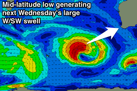 Wednesday's swell will be produced by a broader, stronger and persistent polar low pushing in from the west early next week.
The low will generate a fetch of severe-gale but weakening W/SW winds.
A large W/SW groundswell should be created, peaking Wednesday to 8-10ft across Margs and 2-3ft in Perth. Unfortunately with the low pushing into us, winds will be onshore from the SW, but we'll confirm this on Friday.