Great Saturday, good new swell for Tuesday with not so perfect winds

Western Australia Surf Forecast by Craig Brokensha (issued Friday 25th December)
Best Days: Saturday until early afternoon, Sunday morning in the South West, Tuesday morning both coasts
Recap
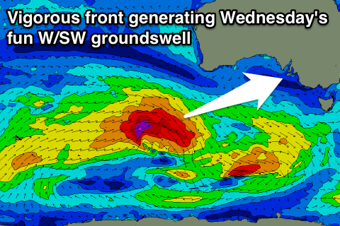
Wednesday's strong kick in long-period SW groundswell eased back a touch into yesterday but continued to provide plenty of size across the South West, best in protected locations with S/SW winds.
Today a large new SW groundswell is on the build, increasing from 6ft+ across the South West, 2ft around Mandurah and 1-1.5ft in Perth with the best winds found to the north.
The swell should reach an easy 8ft across the South West through today, with 10ft cleanup sets, with Perth kicking to 2ft to possibly 3ft but with strong S/SW sea breezes.
This weekend and next week (Dec 26 – Jan 1)
Tomorrow looks great across all regions as this afternoon's kick in SW swell eases under straight offshore E/NE winds, tending variable during the middle of the day ahead of stiff afternoon sea breezes.
The South West should ease from 6ft to possibly 8ft early, with 2ft waves around Perth (2ft+ Mandurah).
Sunday will be much smaller, easing from 3-5ft around Margs and 1-1.5ft up in Perth with E/SE offshores to the south and E/NE winds to the north ahead of sea breezes.
Fresh S/SE winds will return for the start of next week across the South West with a reinforcing SW swell keeping 3-4ft sets hitting exposed breaks, with tiny waves around Perth and an early NE'ly.
 Of greater importance is a better SW groundswell due into Tuesday from a strong pre-frontal fetch of W/NW and then W/SW gales moving through our swell window tomorrow afternoon and Sunday.
A good long-period SW groundswell should result, peaking to 6ft+ across Margs, with 2ft sets in Perth. Winds should swing more SE across Margs, with NE winds persisting in Perth as a surface trough sits between the two locations.
The swell will slowly fade into the end of the week, softened by a reinforcing SW swell as the surface trough moves further east bringing S/SE breezes to both regions. More on this Monday though, have a Merry Christmas!