Improving weekend, best Sunday, good swell building Tuesday with strong offshores

Western Australia Surf Forecast by Craig Brokensha (issued Friday 12th June)
Best Days: Sunday, Monday morning, Tuesday, early Wednesday in protected spots from the strong NE wind
Recap
Slow, peaky start to most regions yesterday before a new W/SW groundswell built into the afternoon as winds tending more N'ly. This W/SW groundswell has peaked this morning but poor S'ly winds limited the best surf to protected spots in the South West, while further north a more variable breeze offered mixed conditions.
 This weekend and next week (Jun 11 - 19)
Today's inconsistent W/SW groundswell should ease back through tomorrow as winds improve and swing SE across all locations.
Sunday looks better though across mainly the Margaret River region as a new SW groundswell fills in offering 4-5ft sets (1ft in Perth) with favourable E/SE winds.
This swell is then due to drop through Monday from the 4ft range as E/SE winds persist.
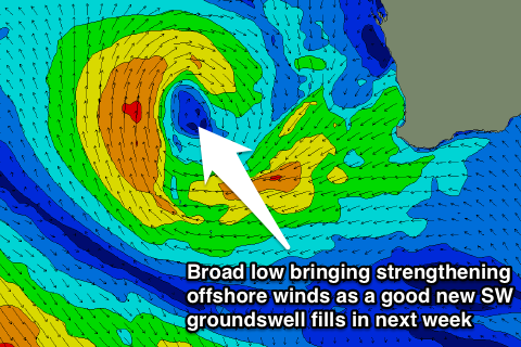
Our better and larger pulse of SW groundswell for Tuesday/Wednesday is still on track, with the vigorous and slow moving polar frontal progression generating it currently sitting just west of the Heard Island region.
The progression should push ease during this evening and tomorrow before breaking down into Sunday.
An inconsistent but strong SW groundswell should result, building Tuesday and reaching 6ft across exposed breaks in the South West with the odd bigger bomb at times into the afternoon, 2ft+ in Perth and 4-5ft+ in the North West later in the day, more so Wednesday.
Winds are looking dicey with a strong but workable E/NE breeze Tuesday, swinging more NE and becoming even stronger Wednesday. This will even affect the North West with E/SE tending N/NW breezes due Tuesday without much strength and then E/NE tending fresh NW winds Wednesday.
A drop in size is then due into the end of the week, with winds swinging more NW as the cut-off low responsible for the poor winds moves in from the west. This will kick up some poor windswell for the North West and Perth but be too far north in latitude to impact Margs.
Longer term, a new S/SW groundswell may be seen Friday afternoon with some closer-range energy over the weekend but with onshore winds. We'll have a closer look at this Monday though as the models are divergent on what will transpire later next week. Have a great weekend!