Small with cyclone swell late week

Western Australia Surf Forecast by Craig Brokensha (issued Monday April 6th)
Best Days: Tuesday swell magnets in the South West, Thursday swell magnets in South West, Saturday morning protected spots for a NW swell
Recap
A slight kick in SW groundswell filled in Saturday afternoon to 3-4ft under offshore winds, while a further kick was seen into the afternoon as winds swung onshore from the S/SW. Perth was tiny and ideal for beginners through the morning.
Sunday saw the swell easing from a clean 3-4ft under all day offshores down South while Perth offered a touch more size with 1-1.5ft sets.
Today the swell was back to a smaller but still clean 3ft around Margs and a tiny 1ft around Perth.
 This week (Apr 7 - 10)
As touched on Friday, there's nothing major on the cards for this week with inconsistent levels of background SW groundswell due through tomorrow and Wednesday to 3ft to occasionally 4ft at swell magnets in the South West with tiny 1ft waves in Perth.
A drop in size is then due Thursday from 3ft or so.
Winds will be favourable for swell magnets tomorrow with a fresh to strong E/NE tending NE breeze tomorrow and then Wednesday looks dicey with N/NE tending NW winds as a weak low pushes across the South West.
Thursday looks clean again with an early E/NE'ly and the S'ly breezes into the afternoon.
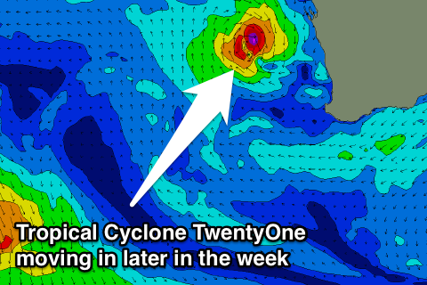
Friday is looking funky as with Tropical Cyclone TwentyOne which is currently south-west of Sumatra expected to race south-east towards us over the coming days before pushing across us Friday.
We're likely to see some small to moderate NW swell building later Friday and easing Saturday from this source and depending on where it crosses the coast, which is currently forecast to be just north of Gero, we'll see S/SE tending S/SW winds.
Size wise Perth may build to 2ft+ late Friday with Margs increasing to 3ft+, peaking early Saturday morning to 2-3ft and 3-4ft respectively. There'll also be similar amounts of SW windswell though from the backside of the ex-TC along with onshore S/SW winds.
All this swell and wind should fade through Sunday under average S'ly winds.
Longer term, as touched on last update, we've got a strong node (peak) of the Long Wave Trough pushing across the Southern Indian Ocean over the weekend and this should bring with it a flurry of strong frontal activity through the Southern Ocean.
The models are still divergent on the structure of this activity but we're looking at some larger swell into the middle of next week. More on this Wednesday though.