Fun weekend, stronger swells Tuesday/Wednesday

Western Australia Surf Forecast by Craig Brokensha (issued Friday 6th February)
Best Days: Saturday morning, Sunday morning, Tuesday morning, Wednesday morning, Thursday morning
Recap
Small waves with light variable winds yesterday morning, while today a lift in swell was seen with workable winds across all regions.
This weekend and next week (Feb 7 - 13)
Today's fresh pulse of W/SW swell is expected to be replaced by a similar sized SW swell through tomorrow across the South West, coming in a little smaller around Perth and Gero.
This was generated earlier in the week by a strong polar frontal progression in the Heard Island region which has since weakened. A secondary weaker polar frontal system is now moving through our south-western swell window and this should produce a smaller increase in SW groundswell through Sunday afternoon.
The South West should see inconsistent but good 4-5ft sets with 2ft sets in Perth and 3-4ft waves up at Gero.
A drop in swell is due through the afternoon with Sunday afternoon's kick in swell coming in a touch smaller than Saturday morning's.
Winds tomorrow morning look good and offshore from the E/SE across all coasts ahead of afternoon sea breezes, and then E'ly winds Sunday morning, likely tending E/NE through the morning around Perth and Gero ahead of an afternoon onshore change. Monday will then see lingering onshore S/SW winds.
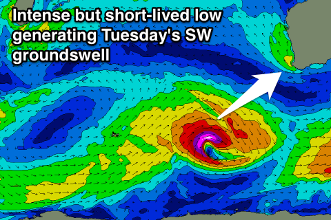 Some better swell energy is due into Tuesday and Wednesday from the SW, an initial pulse arriving through the day Tuesday and peaking midday/early afternoon in the South West with a secondary swell for Wednesday morning.
The first swell will be generated by an intense but smallish and unfavourable tracking polar low, projecting a fetch of severe-gale to storm-force W/SW winds through our swell window. The secondary swell will then be generated by a broader but weaker system firing up on the tail of the low and pushing in a more favourable direction, closer to the south-west of the state.
The Margaret River region should see 5-6ft waves through Tuesday with 2ft+ sets in Perth and 3-4ft waves up at Gero, with Wednesday's pulse coming in at a similar size range.
Winds should improve and swing SE through the morning Tuesday with Wednesday possibly seeing better E/SE breezes. On the backside of the swell Thursday and Friday we look to see winds reverting back to the SE-S/SE but we'll review this Monday.
Longer term we're looking at small to moderate amounts of SW-S/SW groundswell spreading up from a flurry of not overly strong polar frontal activity to our south0west later in the week, but we'll review this Monday. Have a great weekend!