Rare west groundswell Wed/Thu, cleanest Thu morning

Western Australia Surf Forecast by Craig Brokensha (issued Monday 19th January)
Best Days: Wednesday morning, Thursday morning, Friday morning, Saturday morning, Sunday morning
Recap
The South West offered the best waves over the weekend with small levels of easing swell and morning offshores (although a bit blowy Saturday morning, best late morning). Everywhere else was tiny or onshore.
Today onshore winds are in almost everywhere with a slight bump in swell, although Gero saw morning S/SE winds creating OK waves for keen surfers.
 This week (Jan 19 – 23)
Tomorrow looks poor, with a front that was expected to produce a short-range W/SW swell now not expected to eventuate resulting in small waves continuing with onshore NW winds in the South West, variable winds around Perth and morning SE breezes up at Gero.
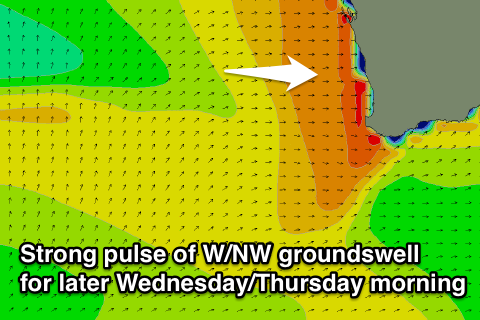
The rare W/NW groundswell due through Wednesday and Thursday is still on track with Severe Tropical Cyclone Bansi slowly moving east-southeast through the Indian Ocean while generating a tight fetch of severe-gale to storm-force NW winds through our western swell window.
Two good but inconsistent W/NW groundswells has been generated for the South West, coming in straighter W'ly across Perth and Gero, with an initial pulse for Wednesday being followed up by a secondary larger kick late in the day and early Thursday.
Size wise Margs and Gero should build to 3-5ft during the day with 2-3ft sets in Perth, while Thursday morning is due to come in at 4-6ft in the South West and Gero, with 3-4ft sets likely in Perth.
After Thursday morning's peak, a steady drop in size is due, but there'll also be a new SW groundswell arriving later in the day, peaking Friday morning (more on this in a second).
Now, winds are looking tricky with a variable tending S'ly breeze due in the South West, while Perth and Gero should see S/SE tending S/SW breezes Wednesday morning.
Thursday looks good for selected locations with a morning SE'ly around Perth and S/SE winds around Margs and Gero.
As touched on above a new SW swell that was last week due on Thursday has been pushed back in timing and also downsized with the polar front generating this swell being a touch weaker and nor projecting as far north-east as it was forecast to.
We're now looking at an inconsistent 4-6ft of swell for Friday morning across the South West with 1-2ft waves in Perth and 2-3ft sets up at Gero, but the easing W'ly swell should be more dominant in these locations from Mandurah north. Winds look to swing more SE across all locations during the morning before sea breezes kick in.
This weekend onwards (Jan 24 onwards)
We should see a series of good S/SW groundswell pulses through this weekend and early next week as a strengthening node (peak) of the Long Wave Trough pushes east and towards the south-east of the country. This will steer a series of strong cold fronts from our south-west up under the country, generating swells that will favour the Margaret River region more so than Perth and Gero.
The first swell is due to arrive later Friday and peak Saturday morning to 5-6ft in the South West, 1-2ft in Perth and 3-4ft up at Gero, with a secondary similar pulse Sunday.
Winds look to be from the S/SE to S/SW Saturday but Sunday looks better with better SE-E/SE offshores due during the morning. We'll review this again on Wednesday though.
Comments
Thanks Craig I fly out Thursday arvo so I should get the best of it early
No worries Blindboy, it's a real tricky one, be interesting to hear the size reports from Thursday morning.
If I have time I will grab a line up shot or two for you.
.
Looking good on the Yalls cam this morning! Nothing big but nice and clean. The Naturaliste buoy picked up the leading edge of this new swell around midnight. Should see a little more size fill in during the day.
It was calm and glassy at dawn but still a bit under sized. By the time I surfed Yallingup the tide and wind were up, but still fun. Maybe try again later.
Was there a noticeable westerly bias in the swell direction?
Definitely Ben, based on the size elsewhere Yallingup would have been a half to a third that size without it. There was still some south around too from yesterday's little pulse which turned out to be pretty good value. The size has picked up since early but it is still inconsistent . I will do a bit of a spot check later to see if it is making it into some of the other spots.
The wind swell has taken over now on Naturaliste buoy .
One perculiarity i saw was that the rottnest buoy went further towards NW earlier than the Naturaliste , could this just be the early stages of the swell when the storm was closer to the equator and bigger cpatured fetch component is still to come . I did note that there was quite a WNW fetch passing yesterday as a sliding front off the remnants of that low . I wouldn't be surprised if late tonight or early tomorrow was bigger than expected . Although regardless the local winds haven't helped , if anything a variable to light humid devil wind NNW would have been better . Maybe try bunker bay later ?!
Its climbing at Naturalist .
Peak period now 20 sec's , avg 14-16 . Still only 1.7m but can only get a little bigger from there .
It definitely took a jump this arvo. Scored some pretty nice waves too, as good as anything I have had this trip. The rip and the wind got it in the end but it was good while it lasted!
southey yeah its come on , rott 3.10 @ 18 wnw now
how were the waves this arvo late on wa far west coasts ?
blindy how did u see the sunset in wa?
Yeah Camel .
I'm spewing . I should of trusted my gut and flew in
. Would have been a fair Pipe impersonation going on.
Let alone " New York "....
I can't view the directional graph on my phone ,
So can only see the avg/mean heights which is lucky
To be 2M . So going in that the peak in avg swell should be
This morning . Damn
Some great waves around this morning, swell kicked after the morning report I came in about nine and it looked like it was still building. The biggest set of the day smashed the whole line up as I was drying myself... It's all in the timing!
How big BB?
Craig's away at the moment but I'll try to update the WA forecast later this arvo.