Slow period ahead of a rare W/NW groundswell

Western Australia Surf Forecast by Craig Brokensha (issued Wednesday 14th January)
Best Days: Perth for beginners tomorrow morning, Gero and Margs Friday and Saturday mornings
Recap
A good pulse of W/SW groundswell held into yesterday morning to an inconsistent 4-6ft across the South West, 1-2ft in Perth and only 2-3ft up at Gero with morning offshores across the southern half of the state. Strong afternoon sea breezes created poor conditions into the afternoon.
Today the swell was smaller and with less favourable winds, but still holding 1-2ft around Perth.
This week (Jan 15 - 16)
Our current easing trend in size should be halted through tomorrow as a new SW groundswell fills in. This swell, generated by a relatively weak polar low over the last couple of days, should offer inconsistent 3-4ft+ sets across Margs, 1-1.5ft waves in Perth and 2-3ft waves up at Gero tomorrow before easing into Friday. Gero will also see some short-range S'ly swell to 3ft as well.
Winds tomorrow won't be great with a fresh to strong S/SE breeze (likely tending SE around Perth) before sea breezes kick in. Friday will be cleaner across all locations with E/SE offshores developing in Perth and up at Gero, with SE (possibly E/SE mid-late morning) winds around Margs.
This weekend onwards (Jan 17 onwards)
A fresh pulse of S/SW groundswell is now on the cards for Saturday morning, mainly across the South West, generated by a deepening polar front as it projects from our south-west towards Victoria. The front will form late in our swell window, with a fetch of W/SW gales falling just within it.
Exposed breaks should offer 3-5ft sets as winds improve further and swing straighter offshore E'ly during the morning.
Sunday will then be average with a surface trough moving inland bringing increasing S/SW tending SW winds.
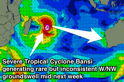 The outlook into next week is quite tricky and dynamic as we're expected to see some long-range and rare W/NW groundswell from Severe Tropical Cyclone Bansi along with some moderate sized SW groundswell from a couple of polar fronts pushing up and merging with the weakening system.
Firstly, STC Bansi which is currently sitting east of Madagascar, is forecast to aim a slow moving fetch of severe-gale to storm-force winds in our swell window while moving east over the coming 4-5 days. While the fetch length and width won't be considerable, the longevity within our swell window should help produce an inconsistent but strong long-period and rare W/NW groundswell arriving early Wednesday, peaking into the afternoon, tailing off slowly through Thursday.
Size wise at this early stage, we're looking at inconsistent 3-5ft waves in Margs, 2ft to possibly 3ft sets in Perth and 4-5ft sets up at Gero.
Before this swell arrives though, a pulse of short-range SW swell is due Tuesday as a strengthening front clips the state Monday evening. The size off this looks limited and only 3-4ft+ in the South West, 1ft+ in Perth and 2-3ft up at Gero with easing SW winds.
Winds on Wednesday as the W/NW swell kicks in are still a little tricky to forecast but we'll probably see variable tending breezes through the morning ahead of afternoon sea breeze. We'll look at this closer as well as the timing/size and longevity of the W/NW groundswell on Friday.
Comments
Craig I suppose it needs more N in it to show waves like the Bianca or Iggy swell, albeit on a smaller scale?
Yeah, it would need a lot more north. This is basically just a standard W'ly swell with a touch of north in it. Bianca was NNW.