Easing swell with slowly improving winds

Western Australia Surf Forecast by Craig Brokensha (issued Wednesday 12th November)
Best Days: Thursday morning in protected spots, Friday morning, Saturday morning exposed breaks (not Perth), Monday morning, Wednesday morning
Recap
Yesterday was average across most spots with a small to moderate swell and increasing onshore winds, but today a strong new W/SW groundswell has filled in reaching 6-8ft across the South West, 3ft in Perth and building from 4-5ft in Gero this morning with favourable winds across most spots at periods through the morning.
Sea breezes have since kicked in favouring protected breaks for the afternoon surf.
This week (Nov 13 - 14)
Today's swell will drop away steadily while swinging more SW in direction tomorrow and S/SW through Friday as a result of the low generating the swell dipping south-east and under us the last day or so.
Winds will remain average tomorrow and strong from the S/SE tending S/SW, while Friday looks fun as winds swing more E/SE through the morning (possibly remaining SE in Margs and Gero). The swell will be much smaller and easing from 4-5ft+ in Margs, 2ft in Perth and 3-4ft up at Gero.
 This weekend onwards (Nov 15 onwards)
Saturday will see better offshore E'ly winds across all locations, even E/NE across Perth and Gero but the swell will be small to tiny and only good at exposed breaks.
Two pulses of inconsistent and smallish background SW swell are due through Sunday and Monday but not above 3-5ft in the South West, 1-1.5ft in Perth and 2-3ft around Gero. Winds won't be great but workable from the SE or so each morning.
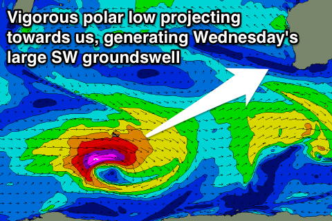
Of greater importance is a deepening polar low in the Heard Island region on the weekend, generating a fetch of severe-gale W/SW winds before weakening while projecting towards us Sunday and Monday before pushing across us Tuesday.
What we should see is a large SW groundswell arriving later Tuesday and peaking Wednesday morning to the 8-10ft range in the South West, 2-3ft in Perth and 4-6ft up at Gero.
Winds should ease after the onshore W/NW tending SW winds Tuesday but likely linger from the W/SW in the South West, with lighter offshore SE winds to the north. We'll have to review this again Friday though.
A secondary strong polar frontal system is expected to slam into us during the end of the week as a strengthening node of the Long Wave Trough develops just to our west. More on this Friday.
Comments
Craig ... where are you????? Need some direction .... LOL
Back today, large strong swell filling in this arvo!
Thanks mate .. time to stash the SUP and bring out the 5m sails ...