Plenty of westerly swell to come but with deteriorating winds

Western Australia Surf Forecast by Craig Brokensha (issued Wednesday 4th June)
Best Days: Thursday, Friday morning, Saturday and Sundaymornings in Perth and Gero, Monday around Gero
Recap
All coasts offered good waves yesterday morning with a light offshore breeze and building groundswell coming in around 6ft+ in the South West, 2ft+ in Perth and 3-5ft around Gero.
Light sea breezes added bumps as the swell continued to pulse into the afternoon.
Today was great again though with a drop in size in the South West and Perth, while a peak to 4-6ft was seen around Gero under offshore winds. Conditions have remained favourable into the afternoon across most breaks as winds have tended variable or light N'ly (in the South West).
This week (Jun 5 - 6)
While a drop in swell is being seen today it will only be temporary as a new strong but inconsistent W/SW groundswell is due to arrive through tomorrow, build slowly through the day and peak Friday morning.
Size wise Margaret River should see 6ft to nearly 8ft sets Friday morning with 2-3ft waves around Perth and 4-6ft sets up at Gero.
Winds will be best tomorrow though and offshore from the E/NE tending variable with the late afternoon more than worth a sniff around. Friday looks a little dicey with fresh NE winds that will tend N/NE through the afternoon, limiting options.
This weekend onwards (Jun 7 onwards)
Saturday will be a poorer version of Friday with a dropping swell and fresh to strong N/NE winds ahead of a shift to the N'th during the afternoon with only protected northern corners due to remain clean.
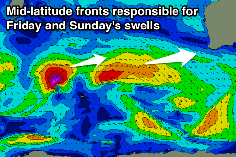 Heading into Sunday a new medium-large W/SW groundswell is due to fill in and peak through the afternoon, generated by a tight but intense mid-latitude low that's currently south-east of Madagascar. This system will track east while generating a fetch of gale to severe-gale W/SW winds through our western swell window today and tomorrow before breaking down tomorrow evening.
The size of this swell should be in the 6ft+ range across the South West into the afternoon with 2-3ft sets later around Perth and 4-6ft waves up at Gero. Winds will remain from the northern quadrant but without as much strength as Friday and Saturday with a NE tending N/NW breeze north of Bunbury and N/NE winds down around Margs.
Monday unfortunately doesn't look any better as a surface trough moves in from the west resulting in fresh N/NW winds in the South West and slightly more favourable N/NE winds further north.
Longer term the run of dicey winds and medium to large W/SW groundswells are due to continue through next week but heading into Friday and the following weekend some larger swell is finally due to fill in.
This looks to be related to a node of the Long Wave Trough amplifying across the South West of the state, directing a couple of strong polar fronts up towards us and through the Bight. Winds may become favourable on the backside of a large peak around Friday/Saturday but we'll have to review this on Friday.