Easing surf with plenty of days to the east

Victorian Forecast by Craig Brokensha (issued Monday July 21st)
Best Days: Today, tomorrow morning to the east, Wednesday Surf Coast, Thursday to the east into the afternoon, Friday/Saturday to the east
Features of the Forecast (tl;dr)
- Easing surf tomorrow with strong N/NE tending N/NW winds
- Moderate sized W/SW swell building through Wed, easing rapidly Thu
- Strong N/NW-NW tending NW-W/NW winds Wed
- N/NW winds Thu, tending N/NE to the east into the PM
- Small, inconsistent SW groundswell for Fri/Sat (possibly undersized early)
- Strong N/NE tending NE winds Fri, strong NE Sat
- Small Sun with N/NW-N winds
Recap
Saturday morning saw a drop in size and northerly winds opening up better options across the Surf Coast beachies and selected locations to the east, while the afternoon cleaned up nicely along the reefs along with a great new pulse of W/SW groundswell.
This swell mixed in with some mid-period energy continued to provide good waves on the Surf Coast into yesterday as winds held from the NW all day, with limited options to the east.
Today the swell is easing from the 3ft+ range on the Surf Coast and 5-6ft to the east. Conditions will remain clean all day for the beaches as winds hold strong from the N/NE.

New swell with cleaner conditions Saturday afternoon

Still chunky on the sets this morning
This week and weekend (Jul 22 - 27)
Following the great run of swell and conditions, the current easing trend will continue into tomorrow, with strong N/NE winds due to shift N/NW through the day.
This will see the beaches performing best in the morning before becoming wind affected into the afternoon.
Size wise the Surf Coast looks to fade from 2ft on the sets with 3-4ft sets to the east.

Our next increase in swell still looks to arrive through Wednesday, with a strong but weakening mid-latitude low due to drop down from the Bight tomorrow evening, generating a tight fetch of gale-force W/SW winds through our western swell window.
This is due to generate a moderate sized spike in mid-period W/SW swell for Wednesday, building towards a peak through the middle of the day, easing Thursday.
The Surf Coast should see 3ft+ waves on the magnets, smaller elsewhere, with 4-6ft sets to the east, easing rapidly Thursday from 2-3ft and 4ft+ respectively west and east of Melbourne.
Local winds will favour the Surf Coast Wednesday and be strong from the N/NW-NW tending NW-W/NW, with the beaches to the east improving Thursday afternoon as a N/NW breeze shifts N/NE into the afternoon across the Mornington Peninsula and Phillip Island.
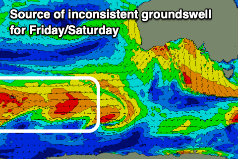
Moving into Friday/Saturday, an inconsistent, small SW groundswell is due, generated by a distant and not overly significant polar frontal progression that’s currently around the Heard Island region.
Size from this source looks minimal with slow 2ft sets due on the Surf Coast and 3-4ft waves to the east under strengthening N/NE-NE winds, favouring the exposed beaches.
The swell might be a little undersized at dawn, strongest into the afternoon, while holding Saturday.
Strong NE winds will continue to favour the exposed beaches to the east on Saturday, shifting N/NW on Sunday as a broad, northerly positioned mid-latitude low starts to move in from the west.
The swell potential from this low now looks minimal with it sitting too far north of our swell window again but check back here on Wednesday for any changes to this outlook.
Comments
Just wondering, is there a schedule to the "arvo'" reporting or are they just random ?
They're for the week days only and usually between 1-3pm latest. Winter time more around 2pm and when there's more light in summer more around 3pm.
Hi Craig, I've noticed for a few months lately on the Vic Surf Coast there has swell, but loads of west in it, so often it's smaller than forecast etc at local spots as some of the swell marches past. Question - is that a symptom this winter, with water not as cold the swell producing lows move to higher latitude and thus more west and less south west/south in swell. If that theory tracks is it fair to think maybe when water warms up as we move out of winter the swell producing lows will form and develop a bit further south, therefore us capturing a more favourable swell direction?
It's been a pattern since the La Nina years kicked in from about 2000 with the storm track generally being positioned a bit more north resulting in more mid-latitude frontal systems and lows which isn't ideal for the Surf Coast. Whether this pattern is part of a longer term shift in the swell climate for the regions is yet to be seen but it could be a hint at what's to come under a warming world.
Thanks Craig
Unreal left at Woolamai right now on the cam! Man they have good banks down there!
Agree there seems to be a lot of more westerly swell in the mix this winter and of recent years. Torquay area still seems to do ok but further down the GOR the size and consistency of sets is quite noticeable. Last Friday and the weekend were good examples.
Spot on
I’d say long term patterns could certainly be at play but at the same time nature does have a mind of its own. Just like a roulette table at the casino it might land on red a few times in a row but doesn’t mean it’s more likely to happen. Some of it might just come down to chance..