Fun run of surf from Wednesday

Victorian Forecast by Craig Brokensha (issued Monday May 9th)
Best Days: Wednesday Surf Coast, Thursday, Friday, Saturday
Features of the Forecast (tl;dr)
- Small mix of easing S/SE windswell and S/SW swell tomorrow with W/NW tending SW winds
- Moderate sized SW groundswell Wed with W/NW tending weak S winds
- Easing swell Thu with light, local offshore winds, variable into the afternoon
- Moderate + sized W/SW groundswell for later Thu, peaking Fri AM, easing
- Light to moderate N/NW tending N/NE winds Fri
- Easing surf Sat with fresh N winds (N/NW to the west, N/NE to the east)
- Inconsistent W/SW groundswell building Sun with strengthening N/NW winds
Recap
Our tricky weekend played out to script with Saturday coming in tiny and clean to the west, while into the mid-late afternoon some new, inconsistent W/SW groundswell started to build, reaching 3-4ft on the Surf Coast magnets right before dark.
Unfortunately the low moved as expected into yesterday bringing onshore winds and poor conditions along with more size, though locations to the east (especially Phillip Island) saw light winds all morning and into the early afternoon as the low’s axis sat across Bass Strait. The mountains got some great dumps of snow which is a great season starter though it looks to be a while before any further dumps arrive.
This week and weekend (Jun 10 - 15)
As touched on last week, the slow moving, cold core low that’s responsible for the current onshore blow will move slowly east tomorrow, allowing winds to back off and even tend variable W/NW through the morning.
This should start to clean up the Surf Coast with a peaky mix of easing S/SE windswell and background S/SW energy to 2ft+ or so.
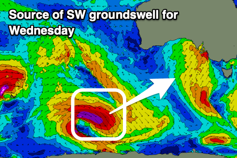
Our better SW groundswell for Wednesday is on track, with a strong polar low forming over the weekend to the east of the Heard Island region, generating a great fetch of severe-gale to storm-force W/NW winds aimed towards the polar shelf.
The swell may be seen on dark tomorrow but should peak Wednesday morning to a good 4ft on the Surf Coast with 6ft sets to the east, easing through the day. Local winds look W/NW through the morning ahead of weak afternoon S/SW winds, smaller Thursday under light, local offshore winds, variable into the afternoon.
Now, our second pulse of less favourably aligned W/SW groundswell for Friday is also on track, with a strong mid-latitude low forming in our far western swell window over the weekend. It’s north in latitude but a great fetch of severe-gale to storm-force W/SW winds have been projected through our western swell window, with the low now weakening on approach to Western Australia.
This should generate another similar sized (to Wednesday) W/SW groundswell for later Thursday but more so Friday morning, with the high likelihood of bigger ones across both coasts in the mix.

Local winds for Friday look light to moderate N/NW through the morning, shifting N/NE into the afternoon as the swell starts to ease, smaller Saturday with fresher N’ly winds (N/NW to the west and N/NE to the east).
Come Sunday, an inconsistent, long-range W/SW groundswell is due from west of the Heard Island region, with a distant fetch of gales expected to generate some slow, small to moderate sized sets into the afternoon and Monday morning.
Of greater significance is some closer range, mid-latitude activity moving in over the weekend, generating some sizier swell for early next week but winds are up for grabs. More on this Wednesday.
Comments
Hi Craig, if you don’t mind me asking do you anticipate this peaky SE windswell to still be in the water early tomorrow?
Not with any size, possibly 1-2ft max I's say and fading.
Thanks!