Fun tomorrow, tricky weekend

Victorian Forecast by Craig Brokensha (issued Wednesday May 4th)
Best Days: Tomorrow (beaches to the east into the afternoon), later Saturday, Sunday Surf Coast
Features of the Forecast (tl;dr)
- Small-mod sized mid-period S/SW swell tomorrow AM, easing with variable winds at dawn, tending N/NW-NW through the AM, then N/NE into the mid-late PM
- Small to tiny, fading swell with early strong N/NE tending N winds
- Moderate sized W/SW swell building later Sat with strong W/NW tending N/NW winds
- Moderate sized SW swell Sun with fresh NW tending stronger W/NW winds
- Moderate sized mix of swells Mon with strong SW winds
Recap
Following Monday afternoon’s change, conditions have been poor and blown out across all locations, with building levels of windswell yesterday and some slightly better mid-period energy in the mix this morning.
This week and weekend (Jun 5 - 8)
As discussed earlier in the week, we’re set to see a rapid turn around in conditions tomorrow as the onshore blow from the last couple of days eases right back and winds become more variable. A N/NW-NW’ly is due to develop through the morning, creating bumps to the east, but during the afternoon winds should swing back N/NE, with the late session being cleanest.
Size wise, some new mid-period S/SW swell in the water this afternoon should hold tomorrow, with sets to 3ft expected across the Surf Coast with 4ft+ sets to the east, easing through the day and much smaller Friday. Fading 2ft sets are due early on the Surf Coast, 3ft to the east but inconsistent.
Strengthening northerly winds are due Friday, making for tricky conditions and only being N/NE at dawn to the east before tending more N’ly.
Looking at the weekend and the evolution of the low and swell pulses have changed a little, with favourable winds still expected though with a shift and downgrade in the timing and size of the incoming swell.
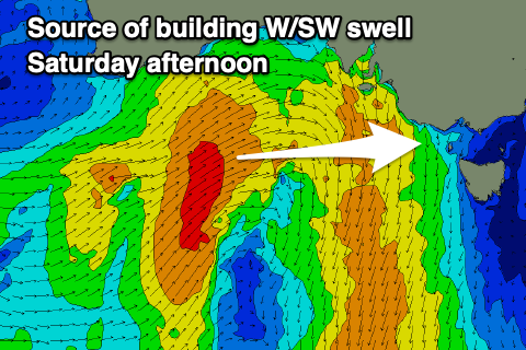
A mid-latitude low moving in from the west will bring with it a healthy mid-latitude frontal system, with a fetch of strong to sub-gale-force W/SW winds now due to sit more in our western swell window as it pushes east tomorrow afternoon and evening.
The track eastward has been accelerated and we’re also due to see a slight intensification on Friday with W/SW-SW gales forming more in our south-western swell window, directly south-west of us.
What this will result in is building levels of mid-period W/SW swell Saturday ahead of a stronger groundswell very late in the day, but more so Sunday morning.
The Surf Coast should build slowly towards 3ft later Saturday with 4-5ft+ sets to the east under strong W/NW tending N/NW winds, with Sunday coming in more around the 4ft range on the Surf Coast and 6ft to the east with fresh NW tending stronger W/NW winds.

The low will stall just west of us during the weekend but aim most of its swell generating winds into South Australia and with this, we’re looking at tricky, sideband energy into us Monday.
We’ll have to confirm things on Friday but it looks like Monday will see similar sized surf to Sunday though the western arm of the low will start to move east, bringing with it strong SW winds.
This isn’t set in stone though as the models are still struggling with this meandering cold pool so check back here on Friday for a more accurate breakdown of the sizes and local winds.
Into the rest of the week we’re looking at smaller surf as the low breaks down and pushes north-east, but check back here Friday for the latest.