Slow period and a reprieve from winter

Victorian Forecast by Craig Brokensha (issued Wednesday May 28th)
Best Days: Surf Coast Saturday morning, Sunday all locations, Monday selected magnets for the keen
Features of the Forecast (tl;dr)
- Fresh S/SW winds tomorrow and Fri with easing levels of S/SW windswell tomorrow, building groundswell energy Fri
- Moderate sized S/SW groundswell for Sat AM, easing and then smaller Sun
- Light W/NW winds on the Surf Coast Sat, variable SW to the east ahead of sea breezes
- Moderate N winds Sun (N/NW to the west in the AM, N/NE to the east in the AM)
- Very inconsistent, small, long-range SW groundswell Mon with fresh N winds (N/NW to the west in the AM, N/NE to the east in the AM)
Recap
Our inconsistent and tricky W/SW groundswell for yesterday came in on forecast, with slow but good 3-4ft sets seen on the Surf Coast magnets under morning offshores ahead of a strong onshore change. Locations to the east were bigger but wind affected and poor.
Today we’ve got some sizey localised windswell but with no quality and with generally poor conditions. Selected protected spots east of Melbourne are offering semi-clean faces but no shape/power.
This week and next (May 29 - Jun 6)
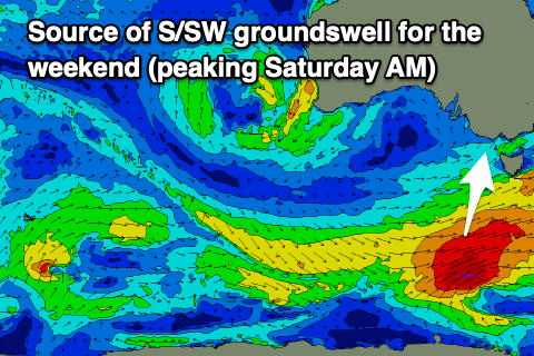
Tomorrow and Friday will be lay days as fresh S/SW winds persist in the wake of the low moving through yesterday along with high pressure stalling in the Bight. Easing levels of windswell are due tomorrow, while into Friday, our moderate sized S/SW groundswell that was due through the afternoon looks to have been pushed back more to Saturday morning and downgraded a touch.
This is thanks to the polar frontal progression linked to it forming a little later in our swell window and being a touch weaker.
The bulk of the swell generation will take place south-west of Tasmania tomorrow afternoon, with a fetch of severe-gale W/SW pushing east through our southern swell window. With a travel time of over a day, we can expect the swell from this source to arrive Saturday morning, with Friday seeing building levels of smaller swell from weaker polar frontal activity today.
Size wise, Saturday morning should come in around 4ft on the Surf Coast with 5-6ft sets to the east, easing steadily through the day and then down from 2-3ft and 4ft respectively Sunday morning.
Winds are still expected to improve for the weekend as the high in the Bight mobilises east, allowing winds to tend more variable and W/NW across the Surf Coast Saturday morning, with light SW tending variable winds to the east (not ideal).
Sunday looks the pick for the beaches with a N’ly offshore, shifting N/NW to the west through the morning and N/NE to the east into the afternoon.
Monday will be smaller again, with a very long-range SW groundswell preventing the coast from going flat. This was generated by a strong polar low that formed south of South Africa and then weakened while pushing east (a long way away). The Surf Coast may see slow 2ft sets on the magnets with 3ft+ waves to the east under fresher N winds (tending N/NW at times to the west and N/NE to the east).
As touched on Monday, the rest of the week looks void of any quality swell as a strong, slow moving mid-latitude low moves in from Western Australia as high pressure sits to its south-east, shutting down our main swell windows.
A trough will bring strong S winds into Tuesday afternoon and Wednesday along with some local windswell, shifting SE Thursday and then to the E/NE on Friday week but with no size. There doesn’t seem to be any change in the pattern until the following week starting the 9th.