Swell delayed to overnight

Victorian Forecast by Craig Brokensha (issued Monday May 26th)
Best Days: Tomorrow morning Surf Coast, Saturday morning, Sunday
Features of the Forecast (tl;dr)
- Moderate sized, inconsistent W/SW groundswell for tomorrow AM, easing with strong N/NW tending W/NW winds late AM, then SW
- Poor surf Wed/Thu/Fri with localised windswell Wed/Thu
- Strong SW tending S/SW winds Wed, fresh to strong S/SW Thu, mod-fresh SW-S/SW Fri
- Moderate + sized S/SW groundswell building Fri, peaking in the PM, easing over the weekend
- Variable offshore winds Sat AM ahead of sea breezes, N/NW on Sun (tending N at times to the east)
Recap
Friday’s strong but inconsistent groundswell eased into Saturday but conditions were great for the Surf Coast with easing 3-5ft sets on the magnets, larger and more wind affected to the east.
A reinforcing W/SW swell maintained inconsistent 3ft waves on the Surf Coast yesterday morning before easing through the day under increasing N/NW winds.
This morning we’ve got a low point in swell, and our new pulse of W/SW groundswell due later in the day now looks very unlikely.
The evolution of the polar front up towards the Bight was a little slower, with the side-band energy now not likely until overnight. Keep an eye on the local indicators for any late sign though as winds shift more N/NW.
This weekend and next week (May 27 - 30)
As touched on last week, the swell generation properties for the incoming mid-latitude low are not good at all for our region, with the low pushing high in the Bight, impacting South Australia mostly before weakening as it slowly moves across us tomorrow.

The stalled movement will bring cleaner conditions tomorrow morning with strong N/NW breezes due to shift W/NW later morning ahead of a SW change.
Swell wise, we’re not expecting any energy from the low itself, with it sitting too far north of our swell window, but swell spreading out radially from the polar front projecting towards the Bight over the weekend.
It’ll be inconsistent but the Surf Coast should come in at 3-4ft on the magnets with 6ft surf to the east tomorrow morning, easing through the day. With those winds, the Surf Coast will be the pick before the change hits.
Now into the rest of the week, we’ll see high pressure follow the low, with it stalling in the Bight as strengthening polar frontal systems fire up to the south-west of Tasmania.
This will bring strong SW-S/SW winds Wednesday with fresh to strong S/SW winds into Thursday. Unfortunately winds will linger from the SW-S/SW on Friday, finally abating on the weekend and tending more variable offshore as the high starts migrating east.
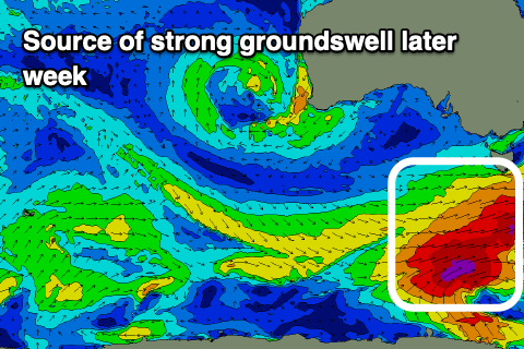
Swell wise, the polar frontal activity will generate a moderate + sized S/SW groundswell for Friday afternoon, easing Saturday, with fetches of gale to severe-gale W-W/NW winds due to kick up solid 3-5ft waves on the Surf Coast, 6ft+ to the east.
The swell will ease back through Saturday from 3-4ft and 5-6ft respectively with those variable offshore winds, N/NW Sunday with smaller, easing surf.
Longer term, there’s nothing significant at all on the cards for next week as a blocking pattern sets up and all the frontal activity is aimed up through the Tasman Sea, but more on this Wednesday.
Comments
Anyone for tennis??
if on a clay court i will defintly.
but forecast says ill be windsurfing. and already have today.
Interesting despite the lack of swell BOM forecasting abnormally high tides along the open Vic coasts into Tuesday with the passage of the low. Was swamping the jettys and coastline in SA today.
Probably because:
https://www.swellnet.com/news/swellnet-analysis/2016/04/19/inverse-barom...
Vic Emergency App warning I've not seen before.
"Advice - Storm Surge - Stay Informed: East Gippsland, South West, West and South Gippsland and Central Districts https://emergency.vic.gov.au/respond/#!/warning/37636 "
Monster high alright
Easter Egg for subscribers:
1:17-1:18pm Torquay North surf cam, no body out.
See if you can see the seal popping it's head up and breaching as it goes up and down the stretch.
Well spotted. Seal having fun chasing something tasty by the looks.
No storm surge though
The Lorne Point cam at 12pm gives a pretty good idea of just how high the tide got. Not that much swell on the Surf Coast to push it up even further I suppose.
Yes, Lorne was fully full! Not much sand to be seen. There was a bit of a swell running Barwon heads way, I guess open coasts bearing the brunt of it.
I don't know if the emergency app helps my state of mind