Dynamic run of swell and winds ahead

Victorian Forecast by Craig Brokensha (issued Wednesday May 21st)
Best Days: Tomorrow morning, Friday selected spots, Saturday Surf Coast, Sunday out of the wind, later Monday Surf Coast
Features of the Forecast (tl;dr)
- Moderate sized, inconsistent W'ly groundswell for later today, holding tomorrow AM, easing
- Variable winds tomorrow morning (SE from about Anglesea west), freshening SE into the PM)
- Large, long-period SW groundswell for Fri AM, easing into the PM, further Sat
- E/NE-NE winds Fri AM, NE into the PM
- Fresh to strong W/NW-NW tending NW winds Sat
- Moderate sized W/SW groundswell Sun with strong N winds
- Mod-large, late increase in W/SW groundswell Mon with strong N tending N/NW then NW winds
- Large SW swell Tue AM with strong SW winds (tending W/SW at times)
- Easing surf Wed with strong but easing SW tending S/SW winds
Recap
A reinforcing pulse of mid-period S/SW swell maintained 3ft sets across the Surf Coast yesterday with generally good conditions all day, workable in the morning to the east but onshore and wind affected to the east.
This morning we’ve got a low point in swell with clean conditions and the best waves on the exposed beaches. Later this afternoon a tricky W/SW groundswell is due but it will arrive a developing onshore breeze as a weakening trough clips us.
The swell should reach 3ft later in the day on the Surf Coast with 4-6ft sets to the east but with a S/SE breeze.
This week and next (May 22 - 30)
Later today’s increase in W/SW groundswell has been generated by a strong but northerly positioned mid-latitude low that moved in and under Western Australia Monday before dropping quickly south-east through yesterday.
The swell should hold tomorrow morning to 3ft on the Surf Coast (inconsistent) with 4-6ft sets to the east, easing through the day.
Local winds look a little better during the morning with the weak nature of the change moving through this afternoon with variable breezes due from about Anglesea east, more SE further west. Winds will freshen across all locations from the SE through the day.
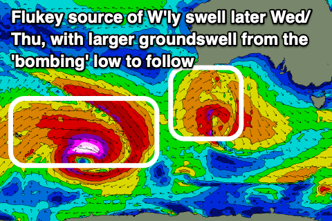
We then look to the large, long-period SW groundswell due into Friday, with the ‘bombing’ low linked to it, currently weakening to the south of Western Australia while still generating fetches of W/NW gales.
Before the low weakened we saw a tight, very intense fetch of storm to hurricane-force winds, abating slowly through yesterday as the low expanded in scope and pushed east.
This has generated a large, long-period SW groundswell with it expected to arrive overnight tomorrow, peaking through the morning Friday to a strong though slightly inconsistent 5-6ft on the Surf Coast reefs with 8-10ft waves across the Mornington Peninsula, easing through the day.
Local winds are tricky and E/NE on the Surf Coast with a more NE flow further east, and with the size of the swell options will be limited. Winds look to hold all day though, NE into the afternoon, with Saturday seeing a shift to gusty W/NW-NW winds, shifting more NW through the day as the swell continues to ease.
The Surf Coast looks to drop from 3-4ft with 5-6ft sets to the east.

Into Sunday, another flukey but decent pulse of W’ly swell is due, generated by a healthy frontal system projecting up towards and under Western Australia over the coming days. The position of this system looks a little better than the swell due through later today and tomorrow morning and with that the Surf Coast may see 3ft+ sets on the magnets with 5-6ft waves to the east.
Local winds look strong from the N’th all day, with similar strong N tending N/NW then late NW winds on Monday ahead of a strong cold outbreak across the state.
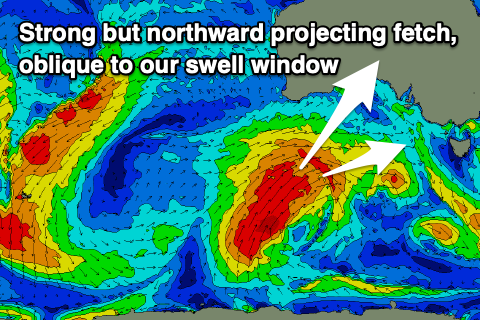
Over the last few days this outbreak was looking more favourable for quality swell production, staying a little further south and stalling just south-west of us, but this morning’s update brings a northward projecting cold outbreak that will bring a ton of wind and lower quality swell.
The source will be a deep polar front projecting from the polar shelf towards the Bight through Friday/Saturday, with a fetch of gale to severe-gale SW winds being projected obliquely through our western swell window.
This will generate a building W/SW groundswell for later Monday afternoon, with the Surf Coast likely to reach 4-5ft before dark with 8ft sets to the east, while come Tuesday, larger surf is due as the low proper moves across us, bringing strong to gale-force SW winds.
A mix of swells to the 6-8ft range are due on the Surf Coast with 10ft sets to the east but with strong W/SW-SW winds.
As the low moves further east into Wednesday the swell will back off and winds look to remain strong from the SW, tending S/SW and easing into the afternoon.
Unfortunately it looks like SW winds will linger into Thursday/Friday as the size continues to drop, cleaner next weekend with some new swells on the cards. More on this Friday.
Comments
Good looking forecast to extend a pretty good month
Craig, any insights into local winds to the west of Cape Otway Friday, models seem to be a bit mixed and trying to get a handle on how much east will be in the wind before booking leave for work?
Looks onnies cac, I’d be going to work and keeping your boss happy :)
So seabreeezes still even when the water is warmer than the land?
Mon and today.
What a good month it's been.
Powerful polar blast:
https://www.weatherzone.com.au/news/powerful-polar-blast-roaring-towards...
Bells 1st June .... https://australianindigenoussurfingtitles.com/