Large, strong groundswell into the end of the week

Victorian Forecast by Craig Brokensha (issued Monday May 19th)
Best Days: Today, tomorrow, Friday, Saturday, Sunday, Monday afternoon
Features of the Forecast (tl;dr)
- Small-mod sized, reinforcing S/SW swell tomorrow with early N tending N/NW winds
- Low point in swell Wed AM, ahead of a new acute W'ly swell later, holding Thu AM then easing
- Mod-fresh NW winds Wed AM, shifting SW into the early PM
- Mod-fresh S/SW-S winds Thu, easing through the day
- Large, powerful SW groundswell for Fri, peaking through the day with NE winds (tending N/NE for a period to the west in the AM)
- Easing swell Sat with N-N/NW winds
- Smaller Sun/Mon with strengthening N/NW winds Sun, NW Mon
- Large W/SW-SW swell likely building Mon PM, peaking Tue
Recap
The weekend was a write-off with a strong onshore change moving in just before dawn on Saturday, with S’ly winds persisting into yesterday. There was plenty of swell though and this morning looks like the pick with easing levels of mid-period energy to 3ft+ on the Surf Coast and 4-5ft to the east under light, local offshore winds.
This week and weekend (May 20 - 25)
Tomorrow will be nice and clean again across the Surf Coast with a N/NW offshore and small reinforcing S/SW swell that should keep the magnets coming in at 2-3ft. To the east, winds will have a bit of north in them and tend N/NW through the morning, becoming more variable into the afternoon. The swell looks to be 4ft+ or so and early will be best when winds are more N’ly.
A temporary low point is due Wednesday morning and with NW tending SW winds into the afternoon thanks to a passing front, options will be limited. Don’t expect much change from 2ft across the Surf Coast magnets.
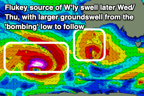
Into the late afternoon and early Thursday, a small pulse of new W/SW groundswell is due, though the source isn’t ideal and local winds look generally poor.
A high riding mid-latitude low pushing under Western Australia is expected to generate a fetch of strong to gale-force W’ly winds through our western swell window, dipping quickly south-east through tomorrow while maintaining strength.
This quick south-east track isn’t ideal at all, as is the initial westerly fetch and this is only likely to result in waves to an inconsistent 3ft or so on the Surf Coast with 4-6ft waves to the east under moderate to fresh but easing S/SW-S winds. There’s an outside chance of early W’ly winds around Torquay for the super keen.
Winds will quickly revert back to the NE on Friday as the swell from Thursday eases, but a strong new W/SW groundswell will take its place, likely there from dawn and peaking through the middle of the day.
The source will be a ‘bombing low’ currently deepening to the east of the Heard Island region.
As this low bombs and reaches an incredibly low central pressure of 926hPa, we’ll see a great but tight fetch of storm to hurricane-force W’ly winds generated in our far swell window, expanding while slowly weakening and moving east through this evening and tomorrow.
With the low maintaining severe-gale W’ly winds in our south-western swell window through tomorrow, only breaking down into the evening, we can expect a large sized, long-period SW groundswell from this source, peaking through the day Friday to 5-6ft on the Surf Coast magnets with 8-10ft sets to the east.
Those NE winds will favour selected spots all day, tending N/NE through the morning to the west.
N-N/NW winds are expected on Saturday as the swell slowly eases, still 3-5ft during the morning on the Surf Coast and 6ft+ to the east.
A further drop in size and consistency is due Sunday/Monday with strengthening N/NW winds on the former, more NW on the latter.
Longer term the outlook is active with the Southern Ocean storm track due to fire up through the weekend and into next week, with favourable winds for protected spots. More on this Wednesday.
Comments
Hold on to your hats gentlemen
This looks good. Some proper surf action is coming !
and the cold has arrived. 2 degrees at first light but water is still warm