Average week of surf, better Saturday and next Monday

Victorian forecast by Craig Brokensha (issued Monday January 20th)
Best Days: Exposed beaches today, Surf Coast Saturday ahead of the change, exposed beaches next Monday
Features of the Forecast (tl;dr)
- Easing W/SW swell tomorrow with variable winds to the west, light E/SE to the east, freshening from the S into the PM
- Strong S/SW tending S winds Wed
- Moderate sized mid-period SW swell Thu with moderate S/SE winds (possibly lighter at times in the AM), shifting S/SW into the PM and strengthening
- Easing swell Fri with strong SW winds, easing and tending a little S/SW
- Moderate + sized SW swell building Sat, peaking later, easing slowly Sun PM
- Light-mod W/NW winds Sat AM, shifting S/SW and strengthening mid-PM
- Fresh S/SW tending S/SE winds Sun
- Easing swell Mon with NE winds ahead of a late S/SW change
Recap
The weekend was best for the beaches with Saturday coming in a little funky thanks to a mix of SE windswell and easing W/SW energy from late last week.
Yesterday was the pick as our new, inconsistent W/SW groundswell started to fill in under offshore winds that remained favourable most of the day.
Besides being great for the beaches, the swell has come in under expectations with the Surf Coast not offering much in the way of surf at all with the SE windswell showing up the best. This morning was cleanest but very slow and hardly 2ft on the magnets, best to the east and a slow 3-4ft.
This week and weekend (Jan 21 - 26)
The current, slow W/SW groundswell will ease back through this afternoon and further tomorrow as conditions come in a little less favourable thanks to a light morning E/SE breeze east of Melbourne, variable to the west.
The Mornington Peninsula looks to ease back from an inconsistent 3ft on the sets, 1-1.5ft to the west.
Winds will freshen from the S through the afternoon, stronger S/SW into the evening as a trough approaches from the south-west and this will then write off the surf into Wednesday with strong S/SW tending S winds.
The trough will spawn off a deepening low to our south-west and with this we should see a pulse of mid-period SW swell for Thursday, though the lack of gale-force winds around the low will produce weak waves to the 3ft range across the Surf Coast with 4-5ft+ sets to the east.
Unfortunately winds will linger out of the S/SE on Thursday, moderate in strength before shifting S/SW into the afternoon and strengthening as the next swell generating system arrives approaches from the south-west (poor Friday with strong SW winds).
Now, as touched on in Friday’s notes, the incoming progression looks quite healthy with it developing in the Heard Island region tomorrow evening, pushing east while generating a great fetch of strong to gale-force W/NW tending W/SW winds.
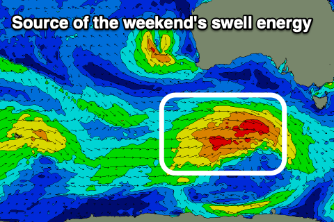
This will produce a moderate + sized mid-period SW swell that’s due to fill in Saturday afternoon but persist Sunday thanks to the prolonged nature and trailing weaker fetch of SW winds on the backside of the progression, south-west of us on Friday evening/Saturday.
The Surf Coast should offer 3-5ft waves into Saturday afternoon (smaller 2-3ft in the morning) and Sunday morning with 6ft to occasionally 8ft sets to the east but with only a window of W/NW winds Saturday morning, shifting strong S/SW by mid-afternoon and then fresh S/SW tending S/SE into Sunday.
Early next week (Monday) looks the pick for the exposed beaches as winds shift around to the NE ahead of the next approaching trough along with good sized, easing surf.
Longer term there’s plenty more Southern Ocean activity on the cards but winds will be tricky. More on this Wednesday.
Comments
Thanks Craig - the charts are currently predicting NE winds on Sunday - are you expecting this to change / push out to Monday?
you read the notes?
I did, I was just querying as to why the forecast winds were out of sync with what Craig was seeing, that’s all
I'm siding with EC while GFS has a better outcome. Let's see how things pan out.
Thanks Craig!
Thanks Craig - on a different note, I am having issues with my app on the mobile and is not opening. Have you had other feedback recently or is this isolated?
Please restart your phone.. this seems to always fix the problem (it's related to a recent Apple update, rather than something we did).
First time in the ments BradPitted69?
I heard you were amped on surfing big Burger World on your recent trip to the Ments Tubba - charging! Also heard you scored A#&! River on the weekend. Care to elaborate?
Hi Craig. I'm interested in your insights (if you have the capacity) on why the long period swell showed on the buoys most of Sunday (period, not height) but was not discernible in the water (whereas it was clearly showing this morning). Is it unusual for forerunners to precede the main swell energy by 12+ hrs?
Great question Nolan, and this was discussed in this article back in 2011. Might need a rehash.
https://www.swellnet.com/news/swellnet-dispatch/2011/04/28/why-swell-tra...
Thanks Craig
The groundswell was discernible on the east coast on Sunday. Very little windswell left in the water
My experience on the MP on Sun was there was a weak 11-12 sec swell in the water and despite a couple of surfs (include a late) and multiple checks I didn't detect anything with the strength or lined-up nature of the 16 sec swell showing on the Nepean (and Sorell) Buoys. Yes, crossed up windswell from Sat had dissipated to only a wobble through the lineup by Sunday.
Yo Swellnet team and contributors, wasnt sure where else to post this - trying to hunt down high res bathymetry of the vic coastline.
Tried one or two gov websites but seems to be haphazard, even when selecting jpeg format I get a link to a zip that has effectively unreadable content aaaarrrrrgggghhhhh!
In this instance I’m chasing in shore bathy for Curlewis and/or the Curlewis bank
Appreciated in advanced
https://maps.garmin.com/en-AU/marine?
Doesn't always work (Garmin have changed a few things) but it's good.
Ya legend benny Enjoy the long Weeknd my friend and come jump on the Autotram Extra-Grand by Gospel & Fraunhofer from Brunswick
erm, OK!
listen to the man
I should open up a business NB - Autotram Extra-Grand Surf Safaris
I could make a motza with my intimate knowledge of surf zones, Swellnets surf forecasts and the Autotrams 256 seat capacity