No let up in the poor wind situation

Victorian Forecast by Craig Brokensha (issued Friday December 29th)
Best Days: Early tomorrow Surf Coast, Monday morning selected spots
Features of the Forecast (tl;dr)
- Moderate + sized SW swell building tomorrow PM, peaking Sun
- Early W/NW winds tomorrow, tending strong W/SW-SW by mid-AM and S/SW into the PM
- Moderate S/SE winds Sun
- Easing swell Mon with E/NE tending S/SE winds late AM
- Moderate sized, mid-period S/SW swell building Tue PM with light-mod S/SE winds, easing Wed with similar winds
- Poor, strong S/SW winds Thu, S/SE Fri
Recap
Poor surfing conditions across nearly all locations with nothing to recommend both yesterday and today.
This weekend and next week (Dec 30 - Jan 5)
Looking at the weekend ahead, and we should see a rapid jump in size through tomorrow as the swell from a strong polar front starts moving in at the same time as winds go onshore from the SW tomorrow morning.
Ahead of this change, a window of W/NW breezes looks slim with it due around dawn, but swinging quickly W/SW-SW by 8am, strong S/SW into the afternoon. The Surf Coast should be around 2-3ft ahead of more size into the afternoon.
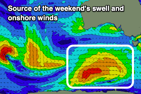
Having a look at the polar frontal progression generating the swell, and a good fetch of strong to gale-force W/SW-SW winds have been generated along the polar shelf, with the front now pushing towards Tasmania.
There’ll be plenty of size attached to it, building to 4ft or so later tomorrow on the Surf Coast, 6ft+ to the east ahead of a peak Sunday to 4-5ft+ and 6-8ft respectively.
Conditions are still set to remain average on Sunday as winds shift S/SE and remain moderate in strength.
Monday morning’s window of E/NE winds is still on track but it’ll be short-lived, with a trough due to swing winds around to the S/SE later morning, fresh into the afternoon.
Size wise, the swell will be on the ease, backing off from 3-4ft on the Surf Coast, 5-6ft to the east, smaller into Tuesday morning as light to moderate S/SE winds persist.
Some fun sized reinforcing S/SW swell is due to arrive through the day Tuesday, generated by a strong polar front swinging in from the south-east Indian Ocean, generating strong NW tending W/NW winds.
The size looks to be around 3ft or so on the Surf Coast, 4-5ft to the east, easing Wednesday but with persisting, light to moderate S/SE winds.
The rest of the week looks poor as high pressure sits south of the Bight, to our west, while polar fronts continue to skirt around the south-east, bringing a return to strong S/SW winds Thursday, S/SE on Friday.
When will this pattern let up? It doesn’t look to be for a while, with the high due to move slowly east through the following week, squeezed by instability to the north-east, bringing an episode of strong E/SE-SE winds and localised windswell again. More on this Monday. Have a great weekend!
Comments
Slave away all year and then this.
More el crapola surf and crowds of holiday people trying to surf it.
:-(
Looks like tomorrow might be kind of surfable. Although I'm not sure I remember how to.
Seriously depressing. After a month on gold coast with no surf now back home and looking the same.
All was a dream winter 23
This Summer is crap and when will it go offshore
March ??
It's time we took matters into our own hands.
Huey provided all winter and now wants a sacrifice from us mere mortals
I say we get down to the bells carpark and destroy all long boards.
That should satisfy him. A cleansing if you like
All long boards in Vicco ridden by under 30s.
Haha WS.
Yeah I should have clarified that a bit more.
But to be fair I think 60 is a better number
Geeze I remember when we used to have days of Nor Easters this time of year with a light sea breeze coming in around 2 to 3 pm (before all the housing estates, asphalt and concrete aka coastal development heat sink makes the sea breeze come in way earlier) then an evening glass off.
Looks like trade winds now.
Off to battle the jet skis, foils, SUPs, Goat boats etc now at that well known offshore in a southerly spot on the entire Vicco coast....its all about timing.
It really wasn’t that long ago. I’ve been on MP 10 years now and the first 4 years or so I would surf before and after work through spring/summer 3-4 times a week with a proper offshore. We would usually get a 2 week straight stretch of southerlies late jan/early feb but that was about it. All changed 2019 with those relentless strong easterlies that fanned the fires then proper La Niña took over. Haven’t been in the water once this month, lucky this weather is perfect for the MTB.
Craig, do you keep the real time wind data for years gone past? Would make for some interesting analysis
It’s nuts eh, what happened to those summers?
2 summers ago (2021/2022) we had a long hot summer, I remember it well. Offered up some really fun surfs with N wind, I surfed in boardies more times than any summer I can remember.
The brutal thing with this summer is not just the direction of the wind, being onshore mainly SE with now some SW, but it’s the sheer strength of the winds. Every day is absolutely howling. Sucks the life out of you!
Yeah I’m not so sure about that dx3.
My memory isn’t recalling anything like that, you may be right but I’d have to look up the data for that summer.
I can definitely remember those summers though when we used to get low-mid 40 degree days a few times each summer and plenty of high 30’s
Yup. I remember getting consecutive hot days. Last 4-5 summers it’s seems to be that we would we get a super hot day with the cool change on the same day (arvo-early evening)
Yeah now it’s one warm day, not stinking hot, and then 5 days of cooler weather
I remember when it would be cold and onshore with glassy off shore waves for weeks, then during the afternoon an early morning warm front would hit, then it would go off shore and choppy for days before it went cross shore and cold but pumping for hours.
Geek - you are the only one who remembers recent summers clearly. First there was a summer of smoke, then 2-3 La Nina’s (+pandemic) and now this summer looks very familiar. DX3 is reminiscent of a hot summer below but he must be tripping. BOM data from Aireys Inlet observations for Jan-Feb for the past 4 years shows a handful of days that made it to 30 degrees, wind aside. That’s Fucken shit. It also ain’t normal. And it certainly ain’t ‘global’ warming. That term is simply incorrect around these parts.
Global Victorian Cooling
with snow on the Otways in winter as well.
Slightly onshore is the new offshore.
We'll always have winter '23.
"Slightly onshore is the new offshore."
haha! (welcome to my stretch of south coast ; )
Are you sure we aren't still in La Nina? Feels awfully familiar.
I’m not fond of criticising folk whose job it is to ‘forecast’ weather and or surf conditions, it’s a mighty task ascertaining how areas of high and low pressure will interact or oppose each other.
Maybe it’s all just a typo, possibly got our ‘La’s’ and ‘El’s mixed up with ‘Nina’s’ and ‘Nino’s’, maybe, just, maybe.
Could easily have been La Nino’s and El Nina’s AW
All I know is that Craig should be Exec Director of the BOM and then maybe we’d have a chance of a decent forecast coming to fruition. At least he gets its right majority of the time. The frauds at the BOM are laughable.
Here in QLD, the SA thread and this VIC one - all seem like this transition / El Nino (but not really) period has been shit for most of the country. Had a beautiful swim in warm glassy water this morning at least, but fangin for a wave.
Happy new year anyway, 2023 was probably the worst year of waves here in at least a decade.
I cannot tell the difference between La Shite and El Crappo.At Least Autumn and Winter in Vic. during 2023 had some good surf but rubbish ski conditions.
http://www.bom.gov.au/australia/charts/viewer/index.shtml
Never seen a synoptic chart like this one before