Poor outlook continues

Victorian Surf Forecast by Craig Brokensha (issued Wednesday 29th November)
Best Days: Possibly next Thursday morning
Features of the Forecast (tl;dr)
- Mod-large, stormy SE windswell today, easing slowly tomorrow and further Fri, fading Sat
- Strong SE winds tomorrow, gusty S/SE-SE on Fri
- Small surf Sat with fresh S-S/SW winds
- Variable winds Sun AM with a small, inconsistent background mid-period swell
- NE tending gusty S/SE winds Mon with tiny surf
- N tending S/SW winds Tue
- Small, inconsistent W/SW swell building later Tue, peaking Wed with S/SW winds
Recap
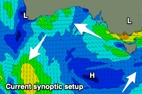
Winds were fairly light state wide yesterday morning as a broad inland low started to drift south-east across the country, bringing freshening onshore winds from the south-eastern quadrant into the afternoon.
The low is continuing south-east while deepening off the far southern NSW coast, squeezing a high sliding under Tasmania, bringing strong SE winds today and localised, stormy levels of south-east windswell.

Satellite capture of the current synoptic setup across the country
This week and next (Nov 29 – Dec 8)
The current interaction between the deepening inland low which is now shifting into the Tasman Sea and the high sliding east under Tasmania will persist tomorrow, though winds look to ease off a touch from today.
Strong SE winds will persist for the most part along with moderate + sized levels of SE windswell, with both easing slightly on Friday as the low starts to weaken and break down.
Fresh and gusty S/SE-SE winds will still blow through Bass Strait on Friday, keeping conditions very poor, while the weekend looks to remain average as we see fresh S-S/SW winds wrapping in behind the backside of the low Saturday.
Swell wise easing levels of SE windswell are due Friday, smaller again into Saturday.
Sunday is a tricky one as instability lingers in the region. This may see winds tend variable through the morning, though likely light S-S/SE'ly, freshening into the afternoon.
Swell wise there's nothing major due with a small, background mid-period SW swell unlikely to top 1-2ft on the Surf Coast and 2ft+ to the east.
Winds look to finally swing true offshore from the NE on Monday but there'll be no swell left in the tank. The Surf Coast looks to be tiny and the Mornington Peninsula 1-2ft or so.
Tuesday morning will remain small to tiny, while some new, inconsistent W/SW swell is due later in the day ahead of a peak Wednesday.
This will be at the same time as another trough brings a S/SW change (N'ly early), with onshore S/SW winds due to persist into Wednesday next week.
The swell isn't significant in any case, generated by a slow moving and unfavourably positioned (too far north) mid-latitude low moving through the southern Indian Ocean.
The Surf Coast isn't expected to get above 2ft with 3ft+ sets to the east into Wednesday but with the onshore winds.
Thursday could be better with easing surf and light, variable morning winds but we'll have to review this on Friday. So all in all the outlook unfortunately remains poor for surfing. Golf anyone?
Comments
South Channel Island SE 34kt gusting 43kt.
Point Lonsdale SE 38kt gusting 45kt.
Cape Otway E/SE 33kt gusting 46kt.
Aireys Inlet SE 21kt gusting 37kt.
Not a fun day in Vicco.
It's our version of a black Nor Easter I guess.
Golf would be a hoot, remember your tie-down points! The birds are hardly bothering to fly today.
Shit. Picked the wrong weekend for a Vicco mission with the grom. Tulla Tub here we come I guess
Yes, it's wild out there on the Surf Coast with a big SE wind swell that will probably bugger up some good sand built up on a few GOR points. On the other hand, it might create a few banks in other places.
Good time to have blown my ACL a week ago, ill be out of the water for a while and this forecast is good for my mental health......
Surfed some fun 2 ft wedges Tuesday in the granite region but probably the strongest off shores I have ever surfed in. Required some belly boarding to get going.
Every 10 mins or so the wind would double in strength and howl down the valleys.
Would this be some sort of pressure build up between the mountains/valleys Craig?
Get this a lot in this region.
Agh, yep, down sloping winds.
Creates stronger gusts thanks to turbulence created from the difference between high pressure at the top of the mountain, where the winds are 'squeezed' by the terrain and a stable layer above it, to lower pressure on the other side where the terrain drops away.
Those isobars south of us next week ... urgh. Where's my Summer, Babe?
A good thing IMO..
look like they are pointed correctly