Hit the beaches today and target protected spots from Sunday

Victorian Surf Forecast by Craig Brokensha (issued Friday 10th November)
Best Days: Today ahead of sea breezes, Sunday through Wednesday mornings Surf Coast
Features of the Forecast (tl;dr)
- Easing swell tomorrow with dawn W/NW winds, tending strong SW shortly after
- Moderate sized W/SW swell Sun with mod-fresh SW winds (W/NW early Surf Coast), stronger S/SW into the PM
- Moderate sized SW swell building Mon (peaking Tue AM) with moderate SW winds (W/NW early Surf Coast), strengthening from the S/SW into the PM
- Mod-large S/SW groundswell building later Tue, holding Wed AM
- Moderate SW winds Tue AM (W/NW early Surf Coast), mod-fresh S/SW into the PM
- Light S/SW winds Wed AM, strengthening as the day progresses
- Easing swell Thu with strong S/SW-SW winds
- Smaller Fri with S/SW winds
Recap
Wednesday afternoon's change eased back rapidly into yesterday morning leaving variable winds and improving surf across all locations with a new pulse of mid-period SW swell. The Surf Coast offered inconsistent 3ft sets across selected locations, 4ft+ to the east, and this morning some spots are still a good 3ft to the west, 4ft to the east.
Conditions are cleaner across all locations this morning and sea fog has just rolled back in (now clearing). Sea breezes are due by mid-afternoon afternoon so surf before then.

Nice conditions to end off the week
This weekend and next week (Nov 11 – 17)
Make the most of the today's waves, as a trough is due to bring a strong SW change around 7am tomorrow, writing off the surf for the rest of the day.
The swell will be smaller, reaching a low point tomorrow morning ahead of building windswell through the afternoon.
Winds will weaken but persist into Sunday morning from the SW, likely tending W/NW for a period on the Surf Coast, along with our new, inconsistent W/SW swell,
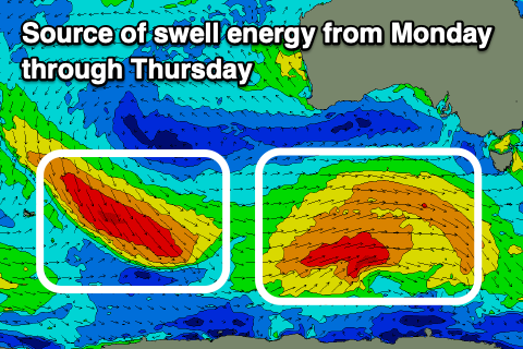
This swell, as mentioned earlier in the week was generated by a broad, slow moving polar low that developed south-west of Western Australia, now weakening south of the country.
Good 3ft surf is due on the Surf Coast (possible rare bigger one magnets) and 5-6ft sets to the east, best in the morning ahead of strong, afternoon SW winds.
Monday looks to play out similar to Sunday but with less wind strength, moderate SW through the morning, strengthening from the S/SW into the afternoon. The Surf Coast should see that window of W/NW winds and swell wise, moderate levels of mid-period SW swell are due to build through the day, produced by a good polar low developing south of the country on the weekend.
It won't be especially strong, but with a broad fetch of strong W/SW winds we should see a good pulse in size to 4ft through the day on the Surf Coast, 6ft+ to the east before increasing a little further into the late afternoon/evening.
Tuesday morning should come in at 4-5ft on the Surf Coast and 6ft+ to the east, though our stronger pulse of S/SW groundswell for the afternoon will boost wave heights more towards the evening.
The source of the stronger groundswell will be a stronger polar fetch of W/NW tending W/SW gales moving in behind the low on the weekend, generating a kick to 4-6ft and 6ft to occasionally 8ft respectively west and east of Melbourne later Tuesday, easing from a similar size on Wednesday morning.
SW winds will persist on Tuesday, light out of the W/NW early on the Surf Coast and moderate to fresh S/SW into the afternoon, while Wednesday looks OK but not perfect with a light S/SW breeze that will strengthen through the morning and afternoon.
Unfortunately these onshore S/SW-SW winds look to persist into Thursday and Friday as the swell eases. The run of average winds is thanks to a strong high sitting under Western Australia we fall under the influence of its eastern flank, squeezed by troughs and fronts pushing under Tasmania.
Cleaner conditions for the beaches are due next weekend with fun levels of smaller swell. More on this Monday. Have a great weekend!