Make the most of today and tomorrow

Victorian Surf Forecast by Craig Brokensha (issued Friday 29th September)
Best Days: Today, tomorrow, Monday exposed beaches for the keen
Features of the Forecast (tl;dr)
- Easing surf tomorrow with local offshore winds (gusty at times), holding from the N'th into the PM
- Easing surf Sun with gusty W/NW tending W/SW-SW winds late AM
- Small, weak windswell for Mon AM, easing with N/NE winds
- Small mid-period W/SW swell Tue with W/NW-NW winds
- Moderate sized, inconsistent W/SW groundswell building later Wed with S/SW winds, peaking Thu with strong SW winds
- Large SW groundswell for Fri with strong S winds
Recap
The swell reached a low point yesterday morning and variable winds created less than ideal conditions before giving into afternoon sea breezes as some new energy started to show.
Today the W/SW groundswell mixed with mid-period energy is coming in nicely with 3-4ft waves on the Surf Coast and 5-6ft sets to the east, best across locations that can handle the size. Winds are due to tend variable this afternoon ahead of late sea breezes, providing plenty of opportunity for a surf.

Good sets this AM
This weekend and next week (Sep 10 - Oct 6)
Looking at the weekend ahead and the current mix of swells are due to start easing tomorrow with the Surf Coast expected to drop from 3ft tomorrow morning (possibly rare bigger set still on the magnets) and 4-5ft to the east, smaller Sunday.
Winds look favourable for both regions tomorrow with a N/NW offshore to the west and N-N/NE winds to the east (fresh and gusty at times), with winds holding from the N'th into the afternoon and evening. This will provide a full day of surf if not watching the big game.
Sunday will be clean early on the Surf Coast with a W/NW-NW offshore but a front will bring a gusty W/SW-SW change through the later morning.
A very weak 1-2ft of windswell is due from this change on the Surf Coast Monday, 2-3ft to the east but with favourable N/NE winds for the desperate. Lower your expectations as the swell will be weak and small.
Looking at the rest of the week, and a small pulse of mid-period W/SW swell is expected through Tuesday, generated by a fetch of strong W/NW winds ahead of a much stronger Southern Ocean frontal progression to the south-west of Western Australia,
No major size is due with slow 2ft sets on the Surf Coast, 3-4ft to the east under W/NW-NW winds.
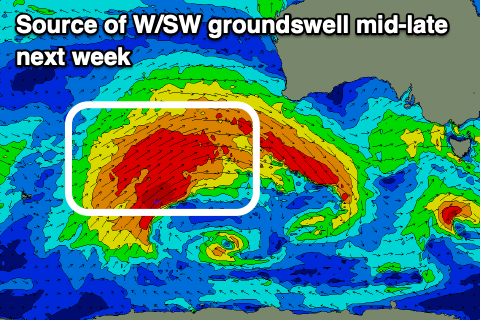
The stronger frontal progression will produce a great, slow moving fetch of gale to at times severe-gale W/SW winds through our medium to long-range western swell window, generating a moderate sized W/SW groundswell that's due to build later Wednesday but peak Thursday.
3-5ft sets are due on the Surf Coast, 6ft+ to the east, but the remnants of the progression are due to move through at the peak of the swell, bringing strong SW winds and some localised windswell.

The models still diverge regarding the timing of this so but Wednesday looks to see the trough moving bringing S/SW winds, strengthening Thursday as it forms into a low.
Following this a larger groundswell is due Friday from a significant polar frontal progression south of Western Australia early next week, but again winds look poor and out of the S'th. More on this Monday. Have a great weekend!
Comments
The computer model doesn’t seem to mind Monday.
Yeah let's see I wouldn't expect much over 3ft.
That polar progression looks very significant indeed!