Poor end to the week, better into the weekend

Victorian Surf Forecast by Craig Brokensha (issued Wednesday 29th August)
Best Days: Saturday morning, Sunday, Tuesday and Wednesday Surf Coast
Features of the Forecast (tl;dr)
- Temp low point in swell Thu AM, with some building mid-period W/SW swell into the PM
- Fresh W/NW tending strong SW winds midday tomorrow
- Moderate + sized mid-period W/SW-SW swell Fri with gusty but easing S/SW winds
- Slight drop in size Sat with an inconsistent W/SW-SW
- Light N-N/NW tending E/SE winds on the Surf Coast Sat, N/NE to the east in the AM
- Easing surf Sun with increasing N/NE winds
- Low point in swell Mon with strengthening N/NE tending N/NW winds
- Moderate sized W/SW groundswell building Tue with W/NW tending W winds, larger into Wed/Thu with winds unknown
Recap
Yesterday morning started small and slow, clean with 2ft waves on the Surf Coast, 3-4ft to the east, building into the afternoon as a new SW groundswell filled in. Good 3ft sets were seen on the Surf Coast with excellent conditions, 4-5ft to the east, while this morning conditions are poor with a gusty SW change and easing surf from 3ft and 3-5ft respectively.
This week and weekend (Aug 30 – Sep 3)
The current swell is expected to reach a low point tomorrow morning, before building back in size tomorrow afternoon, peaking Friday.
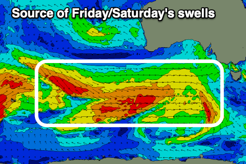
It'll be a moderate sized + mid-period W/SW tending SW swell, generated by a healthy but weakening Southern Ocean frontal system moving in under the country today.
Strong to gale-force W/NW tending weaker W/SW winds should produce a decent sized swell event that will peak Friday but persist Saturday and then start easing through Sunday.
Coming back to tomorrow though and we'll see clean, small 2ft waves on the Surf Coast through the morning with a fresh W/NW breeze, shifting strong SW around midday as the swell generating frontal system clips us.
This will also bring an increase in size, with Friday coming in at 4-5ft on the Surf Coast swell magnets and 6ft+ to the east. Saturday looks a little slow and smaller, back to 3-4ft and 5-6ft respectively ahead of further drop Sunday from 3ft and 4-5ft.
Conditions will unfortunately be poor on Friday with gusty but easing S/SW winds in the wake of tomorrow's change, while Saturday looks cleaner though a little lumpy with a N/NE offshore to the east and N-N/NW winds on the Surf Coast, giving into E/SE sea breezes.
Sunday looks best across the beaches with a moderate to fresh N/NE offshore, strengthening later along with the fun, easing swell.
A low point in swell will be seen Monday along with strengthening N/NE tending N/NW winds ahead of a significant mid-latitude storm pushing through the Bight.

This storm will form off the back of an initial strong system projecting into Western Australia over the coming days, generating a fetch of gales in our far western swell window. This storm alone will generate an inconsistent, moderate sized W/SW groundswell for Tuesday, with the secondary low moving through the Bight expected to generate a larger, more consistent close-range W/SW groundswell for Wednesday/Thursday.
Tuesday's inconsistent groundswell looks to build to 3-5ft across the Surf Coast, 6ft to occasionally 8ft to the east with NW tending W winds, with Wednesday/Thursday looking larger and more to the 6ft range on the Surf Coast. We'll have a closer look at this and the local winds (which look tricky) on Friday.
Comments
At a glance, top screen shot looks like a recipe for consistency?
Or do systems have to slowly move/stall for more consistency?
Yep, should be consistent.
Change in right on cue.