A couple of windows for the beaches

Victorian Surf Forecast by Craig Brokensha (issued Wednesday 18th January)
Best Days: Friday morning keen surfers to the east, Saturday morning to the east, keen surfers to the east Monday morning
Features of the Forecast (tl;dr)
- Moderate sized, inconsistent W/SW swell tomorrow but with strong S winds
- Easing swell Fri with light-mod E/SE tending gusty S/SE winds to the east (SE tending S/SE to the west)
- Moderate sized S/SW groundswell filling in Sat with mod-fresh E tending SE winds
- Small SE windswell for Sat/Sun/Mon
- Easing S/SW groundswell Sun with fresh SE tending strong S/SE winds
- Small, fading surf Mon with E/NE tending S/SE winds
Recap
Good surf across the states beaches yesterday with clean conditions and easing surf from 3-4ft to the east, with 2ft+ waves on the Surf Coast.
This morning there was a brief period of light winds ahead of a strengthening SW change as a surface trough moves through.

The change is in
This week and next (Jan 19 - 27)
Now that the change has moved in proper, we're up for a poor run of surf across the state that will improve slowly into early next week (wind wise) but with no swell.
We've got a good pulse of inconsistent, mid-period W/SW swell due tomorrow, generated last weekend by a broad polar low to the east of the Heard Island region. Conditions will be a mess though with strong S'ly winds persisting in the wake of today's change.
The Surf Coast should see 3ft+ sets with 4-6ft waves to the ease from the mid-period energy, easing Friday as winds ease and tend light E/SE through the morning east of Melbourne.
It won't be great but there should be some options for the keen in selected spots before gusty S/SE sea breezes kick in.
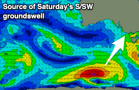
Moving into the weekend, we're looking at slightly more favourable E'ly winds on Saturday morning along with a new pulse of S/SW groundswell. The groundswell is being generated by a deepening but short-lived polar low that's formed south of Western Australia.
A fetch of W/SW gales should generate a good pulse of size to 3ft on the Surf Coast through the day (possibly undersized early) with 4-5ft sets to the east under that morning E'ly. There'll also be some small SE windswell in the mix, with Sunday seeing both swells easing but with unfavourable, fresh SE tending stronger S/SE winds.
Moving into early next week, lighter E/NE winds are due to develop Monday morning but with a small mix of easing swells. The Surf Coast looks to ease back from 1-2ft with 2ft+ sets to the east.
Tuesday morning looks clean again but with a low point in swell.
Looking further ahead and a trough will bring an onshore change on Wednesday and there's nothing significant swell wise on the cards unfortunately.
The Southern Ocean will enter a quiet spell so with this in mind try and make the most of Friday and Saturday mornings.
Comments
It really is the worst SC run in my 30 years of surf obsession.