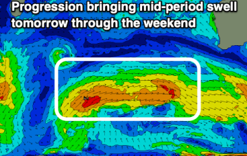
Dynamic period with swells from all directions
Wednesday, 6 April 2022
Dynamic period with swells from all directions
Wednesday, 6 April 2022
Generally favourable winds and swells from the south-east to west.
Generally favourable winds and swells from the south-east to west.
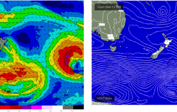
A strong low which passed through the Tasman is also sending a quantum of longer period S to S/SE swell which will see surf heights build from the S to SSE over the next 24-36 hrs.
Fun swells with Perth and Mandurah offering the most favourable winds but the South West will have moments.
TC Fili’s initial WSW to SW movement generated a NE swell that is now supplying really fun surf in the 2-3ft range to the region and this is expected to continue through tomorrow.
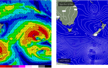
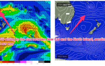
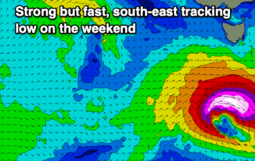
TC Fili is expected to become slow moving as it becomes cradled by the peanut high, with a persistent fetch of E’ly winds supplying an extended run of swell from that direction
TC Fili is expected to track into the slot and stall- roughly equidistant between New Caledonia, the North Island and the East Coast of Australia. At some stage it will lose intensity and become extra-tropical but even as an ex TC the overall cradling fetch of E’ly winds is going to supply days of E’ly swell.
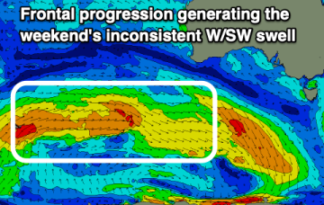
Conditions will slowly improve for the South Coast through the period but with small, inconsistent westerly swells.
The coming period will be tricky regarding local winds and swells more so into next week.
A fun S'ly swell is due through this week, with a reinforcing SE pulse into the end of the week opening up plenty of options.
A large cradling fetch of E to SE winds south of the cyclone is better aimed at sub-tropical areas but should still produce some swell for the East Coast of Tasmania early next week.