Windows of fun surf across all locations

Western Australia Surf Forecast by Craig Brokensha (issued Wednesday April 6th)
Best Days: Tomorrow, Friday morning Perth and Mandurah, protected spots Saturday morning all locations, Sunday morning in Perth and Mandurah, all locations Monday morning, Tuesday morning in the South West
Features of the Forecast (tl;dr)
- Moderate sized, mid-period W/SW-SW swell for tomorrow and Fri with moderate E/NE tending lighter N winds tomorrow, SW tending W/SW Fri (light offshore Perth and Mandurah in the AM)
- Slightly smaller, steadying surf Sat with strong S/SE tending S/SW winds
- Inconsistent SW groundswell Sun with SW tending fresh S/SW winds in the South West, light E tending SW in Perth and Mandurah
- Easing SW groundswell Mon with SE tending SW winds, smaller Tue with E tending S/SW winds
Recap
Great conditions with easing 3-4ft sets in the South West yesterday but interestingly, still 2ft across Perth and Mandurah. The swell faded through the day and this morning it's tiny across metro locations with inconsistent 2ft to occasional 3ft sets in the South West.
This week and weekend (Apr 7 - 10)
We've got a renewal of swell energy into the end of the week, that being a fun mid-period SW swell that's due to fill in tomorrow (likely undersized early) and peaking through the day, easing slowly Friday morning from a similar size to tomorrow afternoon.
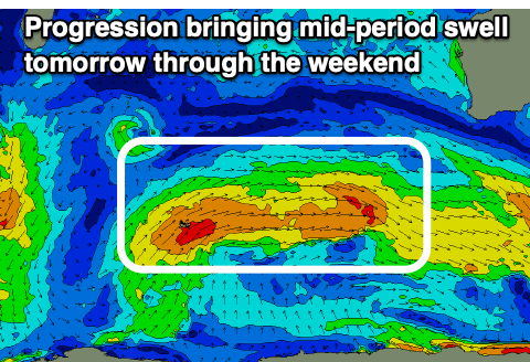 The source of this swell was back to back frontal systems pushing up through our swell window without any major strength but we should still see the South West reach 4-6ft with 1-2ft sets in Perth and Mandurah.
Winds will be best tomorrow and moderate out of the E/NE in the morning, shifting N'ly and easing into the afternoon/evening. Friday unfortunately sees a trough bringing a SW change around dawn in the South West but Perth and Mandurah should light offshore winds ahead of the change.
The trough will clear to the east on Saturday as a ridge of high pressure fills in, swinging winds to the S/SE and with strength as the swell steadies but weakens with a small, background mid-period swell.
Unfortunately another trough is set to bring SW winds to the South West on Sunday (light E/NE to the north) as a better though inconsistent SW groundswell fills in.
The source of the groundswell was a strong but distant polar low that formed west of the Heard Island region earlier this week, generating a great fetch of gale to severe-gales.
Sets to an inconsistent 6ft to occasionally 8ft are due in the South West with 2ft sets in Mandurah and 1-2ft waves across Perth.
Monday looks cleaner as winds revert back to the SE again but the swell will be easing in size from 4-5ft in the South West, 1-1.5ft further north.
The swell will continue to ease as winds improve further on Tuesday and Wednesday but the South West magnets are the only option.
Longer term a large blocking high (linked to the offshore winds) will keep things fairly subdued until the weekend where we might see a fun SW groundswell filling in. More on this in Friday's update.