Fun surf to end the week, tricky until next week
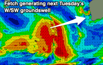
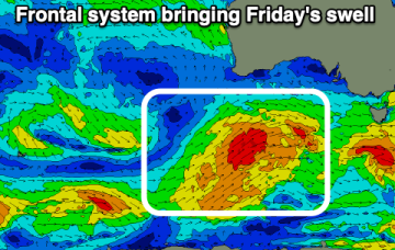
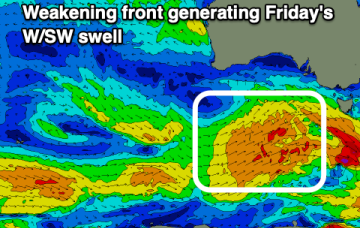
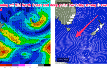
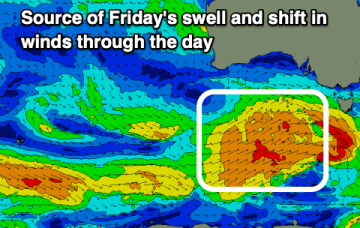
Good swells and decent winds Friday ahead of average conditions on the weekend and fun surf next week.
The current pattern- with weak high pressure drifting across Central NSW and a soft ridge along the coast- will be replaced in emphatic fashion by a much stronger front and trough on Friday, forming a surface low off the Mid North Coast, anchored by a monster high moving into the Bight at the same time. Well to the south of that set-up will be a deep polar low and associated fronts with severe gales to storm force winds generating long period S’ly swells to make landfall over the weekend and into early next week.
The current pattern- with weak high pressure drifting across Central NSW and a soft ridge along the coast- will be replaced in emphatic fashion by a much stronger front and trough on Friday, forming a surface low off the Mid North Coast, anchored by a monster high moving into the Bight at the same time. Well to the south of that set-up will be a deep polar low and associated fronts with severe gales to storm force winds generating long period S’ly swells to make landfall early next week.
A little windy to end off the week but offshore and with a good SW groundswell.
The current pattern- with weak high pressure drifting across Central NSW and a soft ridge along the coast- will be replaced in emphatic fashion by a much stronger front and trough on Friday, anchored by a monster high moving into the Bight at the same time. Well to the south of that set-up will be a deep polar low and associated fronts with severe gales to storm force winds generating long period S’ly swells to make landfall early next week.
Make the most of the current favourable conditions and swell today and tomorrow morning. There'll be fun sets in the gulf Friday for the keen.
Good surf across most locations this afternoon and tomorrow morning ahead of a run of onshore southerly winds.
A much stronger change on Sat looks to form a low in the Central/Northern Tasman with a more substantial swell increase also being generated by a deep polar low transiting the Tasman.
Slow over the coming days ahead of increasing swell activity into the weekend and early next week.
Not a great deal of action on the charts to start the last week of Winter. A strong high (1040hPa) is on the other side of New Zealand but pressure gradients in the Tasman are weak, with minimal swell energy being generated from that source. Later in the week, Tradewinds do poke their head up over New Zealand and generate some useful E swell.