Great surf this afternoon and fun tomorrow morning

South Australian Surf Forecast by Craig Brokensha (issued Wednesday August 31st)
Best Days: This afternoon both coasts, South Coast tomorrow morning, Mid Coast Friday, South Coast for the keen Sunday morning but more so Monday and Tuesday mornings
Features of the Forecast (tl;dr)
- Reinforcing mid-period SW swell Wed PM and Thu AM with a stronger SW swell Fri
- Local offshore winds tomorrow morning, tending SW late AM and then fresher S/SE later
- Mod-fresh S/SE winds Fri (SE early-mid AM on the Mid)
- Easing SW swell Sat with light-moderate SE winds, increasing
- Smaller Sun with E tending SE winds
- Small Mon with NE tending E/SE winds
- Small S swell Tue with NE tending E/SE winds
Recap
Poor conditions and a bit more size on the Mid Coast yesterday with a mix of groundswell and mid-period energy under strong SW winds. Conditions improved into the afternoon and the incoming tide helped maintain 2-3ft sets. The South Coast was solid and to 4-5ft but choppy in the morning, and conditions also improved into the afternoon as winds eased and tended more W/SW.
Today, conditions are much better with a little less swell again, fun and to 3ft on the South Coast, 1-2ft on the Mid. Winds are due to tend variable across both coasts into the mid-late afternoon offering fun options for the late session along with a fresh pulse of mid-period SW swell.


Great surf continues across both coasts today
This week and next (Sep 1 - 9)
Later in the day today, the first pulse of reinforcing mid-period SW swell is expected, easing through the day tomorrow ahead of a stronger pulse of SW groundswell energy on Friday.
The first pulse of swell was generated by a healthy but weakening polar front moving in from the Heard Island region on the weekend. It should come in at 3ft+ across Middleton later today and tomorrow morning while the Mid Coast looks to come in at 1ft or so.
Winds look great tomorrow morning with variable offshore breezes, N/NW down South and E/NE on the Mid Coast, giving into a shallow SW change late morning ahead of a stronger S/SE breeze later as a trough moves in from the west.
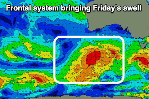 This trough will unfortunately spoil Friday's swell on the South Coast with moderate to fresh S/SE winds due to blow all day, but the Mid Coast looks decent all day with a SE tending S/SE breeze.
Swell wise, the front linked to Friday's strongest pulse of size is currently passing south of the Bight, generating a healthy fetch strong to gale-force W/SW winds in our south-western swell window. With the front having polar origins, it's persistent nature should generate 4-5ft waves across the South Coast Friday with inconsistent 1-2ft surf on the Mid Coast.
The swell will start to ease into the weekend and with lingering light to moderate SE winds, favouring the Mid Coast for beginners while the South Coast looks bumpy with easing 4ft sets across Middleton.
Winds will take their time to swing offshore owing to a strong polar frontal progression firing up south of Tasmania, blocking a high moving in from the west. This will result in E'ly winds on Sunday as the surf continues to drop in size, back from 3ft. The Mid will be tiny to flat.
Early next week still looks the pick with a morning NE offshore on Monday, E/SE into the afternoon and similar Tuesday.
Swell wise, Monday looks smaller and to 2ft+ across Middleton, while a small pulse of mid-period S'ly swell is due off the polar frontal progression south of Tassie on Tuesday but only to 2ft on the sets.
Longer term an inconsistent W/SW groundswell is due later week ahead of some possible larger, windy surf next weekend. More on this Friday.