Great action for protected spots, beaches mid-late next week

Victorian Surf Forecast by Craig Brokensha (issued Wednesday 4th May)
Best Days: Today protected spots, tomorrow morning protected spots, Friday Surf Coast, protected spots Saturday, Sunday morning Surf Coast, Monday morning, beaches Wednesday through Friday next week
Features of the Forecast (tl;dr)
- Building moderate sized + mid-period W/SW swell today with freshening NW tending W/NW-W winds
- Mod-large, inconsistent W/SW groundswell for tomorrow AM, easing slowly with W/NW tending W/SW-SW winds around midday
- Easing surf Fri with strengthening NW tending W/NW winds
- Moderate sized + localised S/SW swell for Sat with strong W/NW-W winds
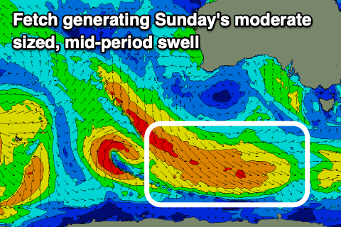
- Easing S/SW swell Sun with a new, moderate sized mid-period SW swell with W/NW tending SW winds mid-late AM
- Easing SW swell Mon with variable tending SE winds
- New W/SW swells mid-late next week with NE-N/NE winds
Recap
Increasing wind but really fun surf across most of the state yesterday with an inconsistent pulse of SW groundswell seen Monday afternoon to 3-5ft on the Surf Coast, easing back from 3-4ft. The Mornington Peninsula was in the 4-6ft range, easing during the day but becoming wind affected.
This morning we've got a little less size and period to the swell but clean conditions across the Surf Coast and 3ft sets, bumpy and 4-5ft to the east. We should see some larger mid-period W/SW swell building through the day with a very late signal of long-period energy (more so tomorrow), but more on this below.
This week and next (May 5 - 13)
The remnants of the strong storm progression linked to our building swells during today is now moving across the state, bringing this showery and cooler weather. We'll see snow across the alpine regions as a broad, multi-centred low forms over the state, influencing our weather, winds and surf from now until Sunday.
Coming back to the swell generated by the initial stages of the progression, which started its life late last week, west of the Heard Island region, and this swell was the one seen building across the Margaret River region yesterday.
There's a mix of swells due, with initial mid-period W/SW energy generated by the final stages of the progression due to fill in today, providing the most consistency, while the less consistent but stronger long-period energy should arrive this evening and peak tomorrow morning.
Building sets to 4ft+ are due on the Surf Coast this afternoon, 6ft+ to the east. Winds could remain favourable and hold from the W-W/NW into this evening, otherwise only being W/SW and favouring protected spots.
Tomorrow should see a mix of mid-period and groundswell energy with sets varying between 4-6ft on the magnets (very inconsistent in the upper range) with 8ft bombs on the Mornington Peninsula (again very inconsistent).
Winds will continue to favour protected spots with a morning W/NW breeze, shifting W/SW-SW into the afternoon as the swell eases.
Friday looks great all day with a strengthening NW tending W/NW breeze with easing sets from an inconsistent 3-4ft on the Surf Coast, 4-6ft to the east.
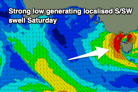 Now, moving into the weekend, and the broad, multi-centred low will strengthen into Friday evening and Saturday, with a fetch of strong to gale-force S'ly winds due to be generated right off Tasmania's West Coast, in our southern swell window.
This will generate a moderate sized, localised S/SW swell for Saturday to 4-5ft+ on the Surf Coast and 6ft to possibly 8ft to the east. The swell will arrive with strong winds, though likely holding from the W/NW-W all day. Sunday morning looks clean with a moderate to fresh W/NW breeze, though shifting SW through the day as the low weakens and starts to move off to the east.
Swell wise, the localised S/SW swell will ease rapidly but some new, mid-period SW swell from a healthy fetch of strong to gale-force NW tending W/NW winds tracking along the polar shelf should steady wave heights.
The Surf Coast should hang around 3ft+ all day with 4-5ft+ sets to the east, but best early ahead of that SW change.
 Come Monday winds are due to tend more variable as the swell eases from Sunday, dropping from 3ft and 4ft+ respectively.
As touched on in Monday's update, a strong high moving in slowly from the east will dominate our outlook next week with fading surf under E/NE winds due Tuesday.
An inconsistent mix of new W/SW groundswell and mid-period energy is due Wednesday/Thursday though under favourable NE-N/NE winds, generated by good frontal progression firing up south-west of Western Australia later this week and into the weekend, but we'll have a closer look at this Friday.
Comments
now that's what we've been looking for, maybe the colder weather might also drop off the numbers a bit
Highly unlikely
Its still 16.5 in the water. That aint bad at alllll for May
Sing hallelujah! Sing it Craig!
Hey Craig - there's an error in the web page links. When I click from this VIC 'forecasters notes' tab through to the 'Surf forecast' tab its taking me to the Gold Coast forecasting page. FYI
Ah that's always been the case re goes to the Forecaster Notes region depending on last report/forecast you looked at.
So stop looking at Qld and stay on Vic ;) Ha
Haha. Yup. I get missing node or something. Well there ya go
The late autumn surf is improving just as my car has failed and is not operable. :-(
FOMO is a real thing, it's a living thing .
Swell looks underwhelming this morning :/
Hopefully the incoming tide gives it a little kick along
'(very inconsistent in the upper range)' you can say that again
It didn’t!
Who posted 6 /10 this morning
Clearly tripping
Maybe making up for yesterday's 4/10 (in reverse)?
How about just go surf instead of over thinking the score
Get out there !!!
Spoken like a scorned reporter! Hahah
Think old beggsie is on the otherside. More spoken like a scorned raving lunatic (see monday notes)